Tuesday, July 30, 2013

Ottoman and Arab Maps of Palestine, 1880s-1910s

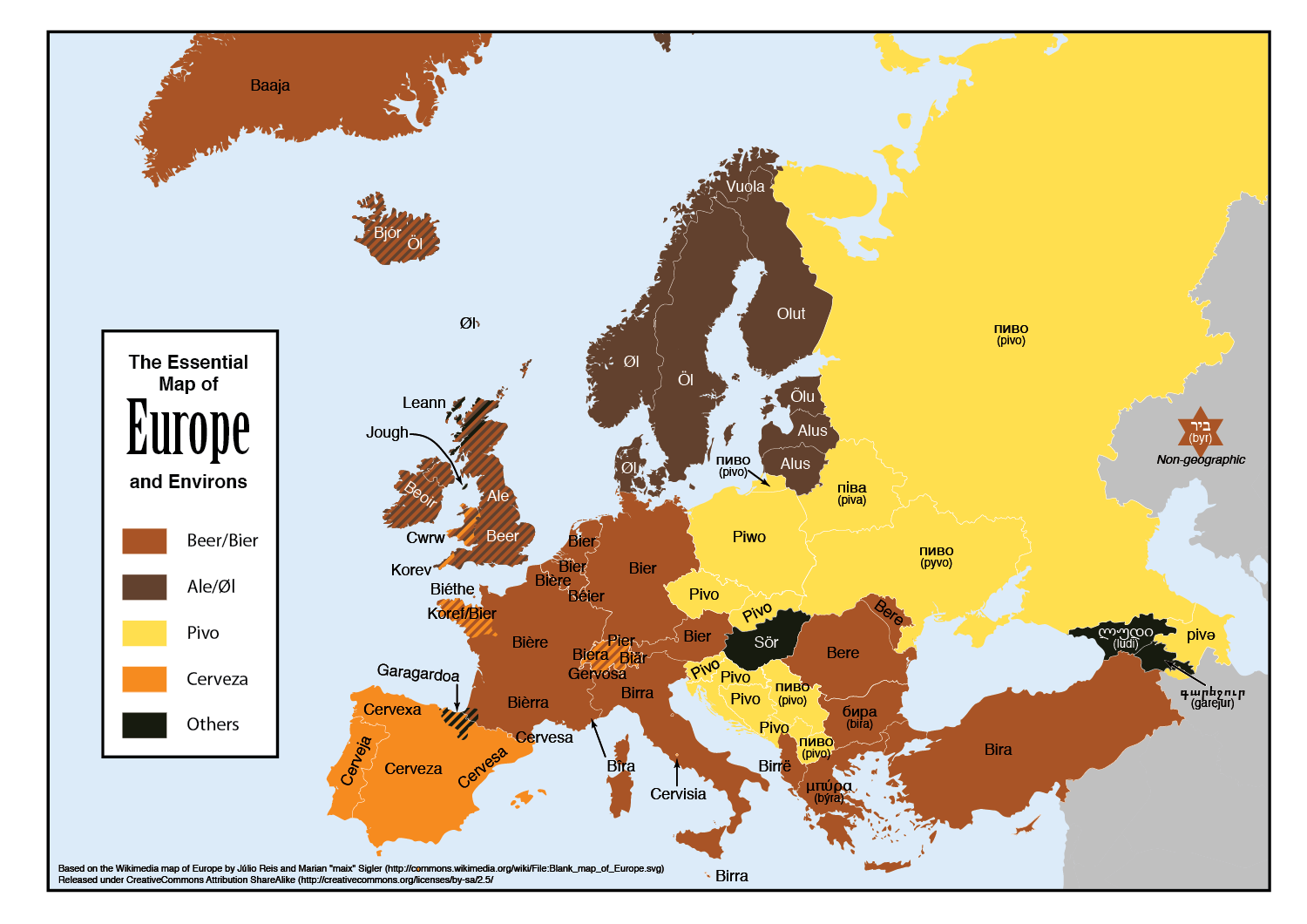
By: Zachary J. Foster 

Academics have long concerned themselves with maps of Palestine.  But almost all of the published literature on Palestine maps– including the publication of the maps themselves – has dealt with those maps published in Europe by Europeans.  But what about the Ottoman administrators who ruled over Palestine, and those (primarily Arabic speakers) that lived in Palestine?  How did they imagine Palestine in the late nineteenth and early twentieth century?  The largest collection of ‘Palestine’ maps available on the web from the Ottoman period, for instance, some 166 maps – contains a whopping total of ZERO maps produced in the Ottoman Empire.[1]  Below, I would like to offer a few very preliminary comments on how the Arabs and Ottomans cartographized Palestine in the late nineteenth and early twentieth centuries.


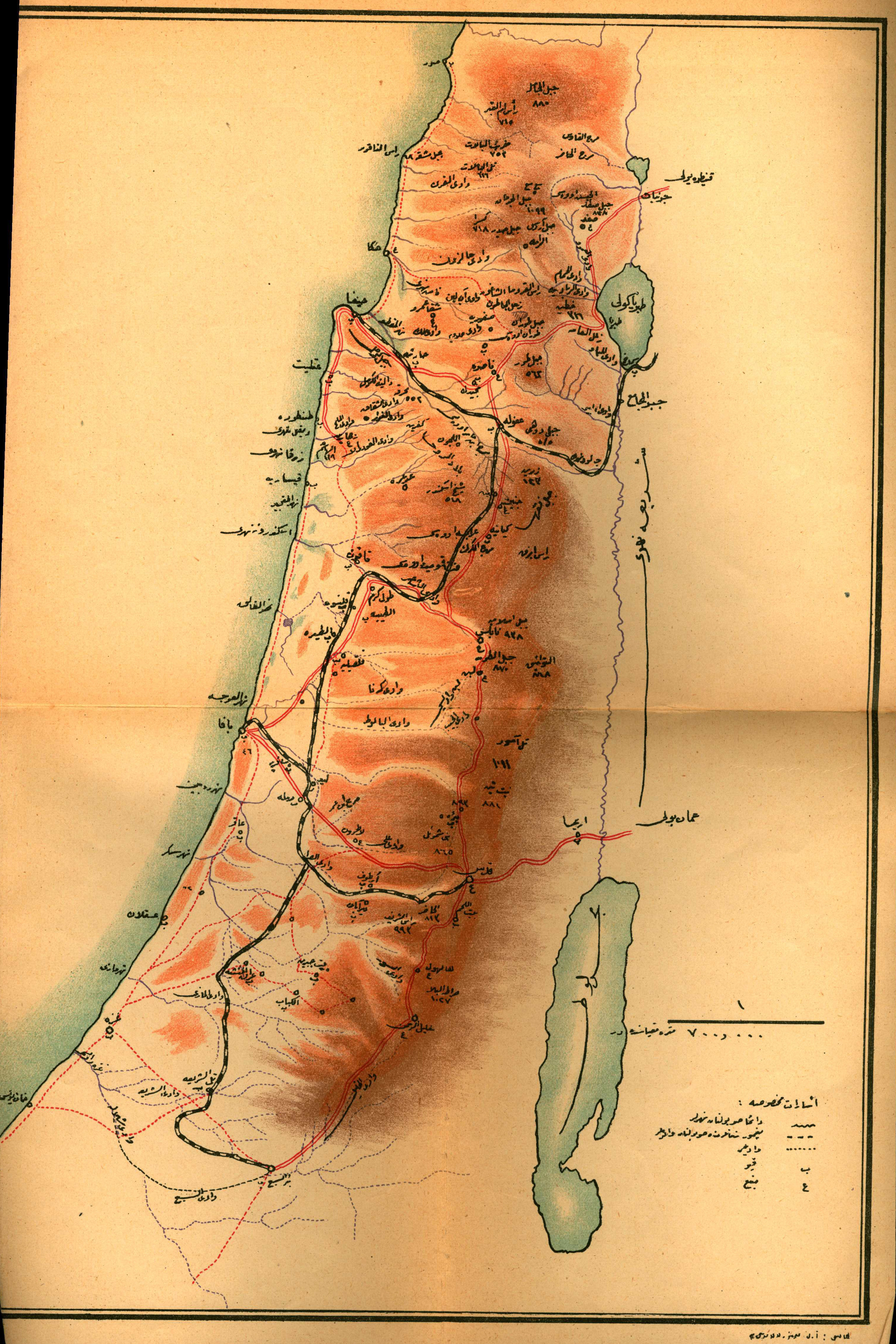
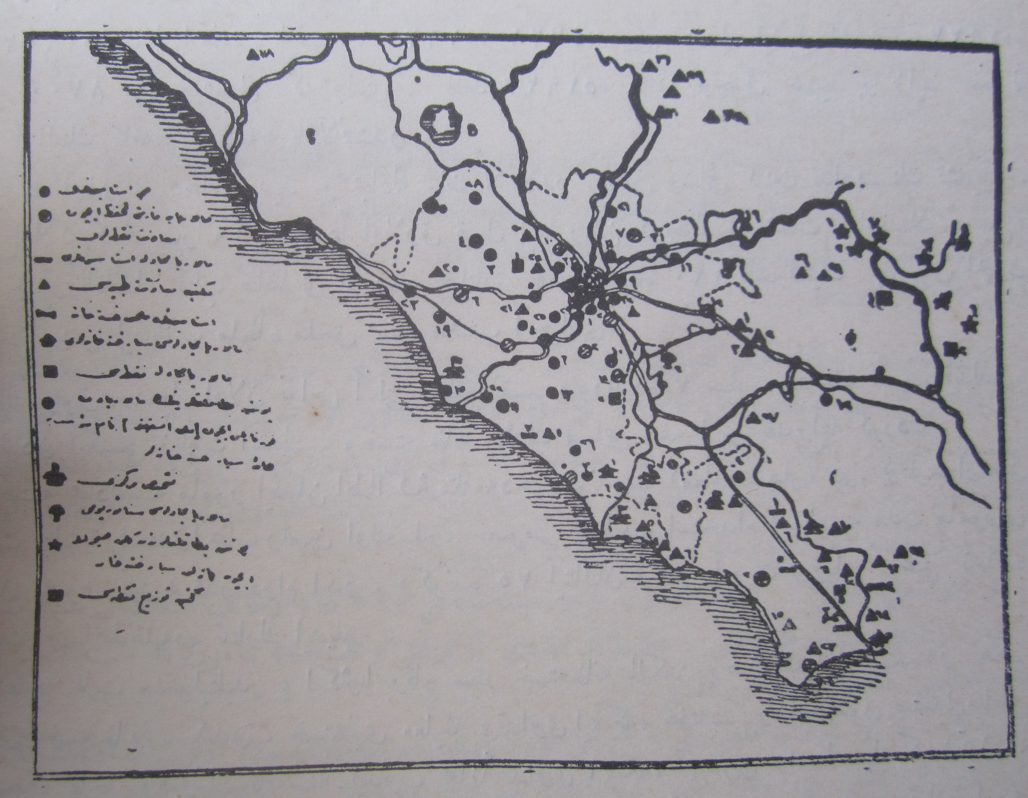
The first map in this collection was published in Filastin Risalesi, an official publication of the Ottoman army intended to be used as an officer’s manual for the Palestine region.   The manual itself is a social, topographical, demographic and economic survey of Palestine circa its time of publication, 1331 (Rumi).[2]  It is actually a quite unremarkable work, and resembles much of the ‘geographical’ literature published in both Ottoman and Arabic in the late nineteenth and early twentieth centuries.  The map itself, just as the rest of the book, is published in Ottoman Turkish, and includes both topographical features, such as rivers and mountains (the darker the color, the higher the altitude), as well as all of the major towns and cities. 

It is worth noting as well that the version of Palestine represented in this map bears heavy European influences.  In much of the European geographical literature of the 19th century, as Gideon Biger tells us, Palestine extended from Rafah (south-east of Gaza) to the Litani River (now in Lebanon), from the sea in the west, to either the Jordan River or slightly east of Amman in the East.[3] This is more or less the Palestine that we see on the map.  Notice, as well, that that there are no lined-borders, only a very general sense of Palestine as a region.  This was common for the period as well.  Finally, the southern desert, or Naqb (Negev in Hebrew), is not included in the map, a common feature of European, Ottoman and Arab maps of the region in the late nineteenth and early twentieth centuries.  South of Beersheba was wilderness, both beyond the purview of Ottoman imperial authority, and therefore also beyond the purview of Palestine. 


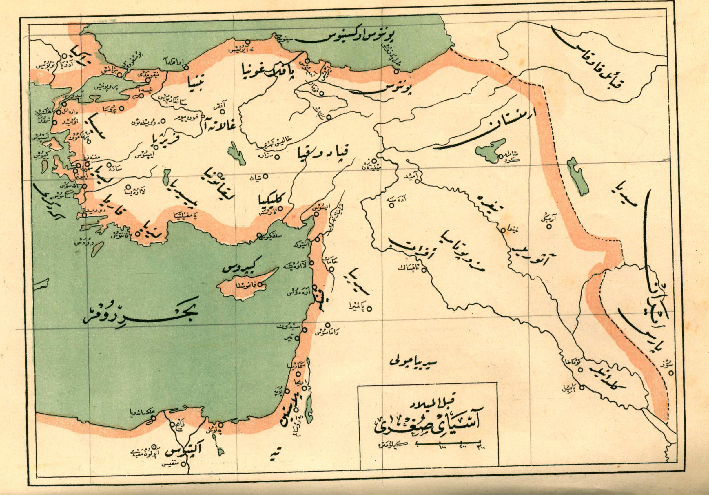
Now we shall turn to another series of maps published in book titled Jughrafiya-i Osmani (1332).  The first map of Palestine in the book is actually not a map of Palestine per se, but a map of Asya as-Sughra (Asia Minor) qabla al-Milad (before the birth of Christ).  This is quite an interesting map insofar as it attempts to portray the political geography of the region as it looked liked in the pre-Christ period.  Anyone with even a passing knowledge of European intellectual history of nineteenth century knows that what was interesting to write about, what was worth knowing, studying and digging up, was ancient, biblical history.  Thus the European growth of ‘bible studies’ had a profound impact on Ottoman thinking, something that surfaces in this map here.  Hence, the word ‘Palestin’ is written with the letter ‘pe’ in Ottoman Turkish – something I have only found on this map.  It is also worth noting that the word ‘Palestin’ is written over only the very southern most area the settled part of the Levant (inside, even the city of Ahira (Jericho) is north of the ‘Palestin.’  This, again, reflects a classical geographical understanding of Palestine – which included the southern coastal strip from Gaza to Jaffa, or the territory inhabited by the Philistines, or ‘Plishtim,’ in Hebrew.   Other noteworthy markers on the map in include ‘Samarya,’ (Samaria), Damasus (Damascus), Palmayra, Tayr and Yupa (?). 


Our next map, like the rest in Jughrafiya-i Osmani (see 90, 101, 104, and 116), make no mention of Palestine anywhere.  This was not uncommon for the period, as Palestine did not constitute an administrative district in the Ottoman Empire.  Instead, the entire region is labeled ‘Suriye’ in all of these maps. 


Now we turn to another map in Jughrafiya-i Osmani (after p. 98) which does in fact mention Palestine, now spelled in standard Ottoman (as well as Arabic) way rather than spelled as a transliteration of the Latin word Palestina.  This map claims to be a map of the Ottoman administrative geography (taksimat-i idariya), which is interesting because, as we just stated above, Filistin was NOT an administrative unit in the Ottoman Empire.  The region in which Filistin appears in this map (in between the two horizontal lines) was in fact the Mutasarıflık (Mutasarifiyya, in Arabic) of Jerusalem, of Kudüs-i Şerif.  Indeed, it was not uncommon in both Ottoman and Arabic geographical thinking to regarding ‘Palestine’ as synonymous with this administrative district.[4] This was a curious blend of the way the Ottoman administered the region – and the way the Europeans labeled them. 


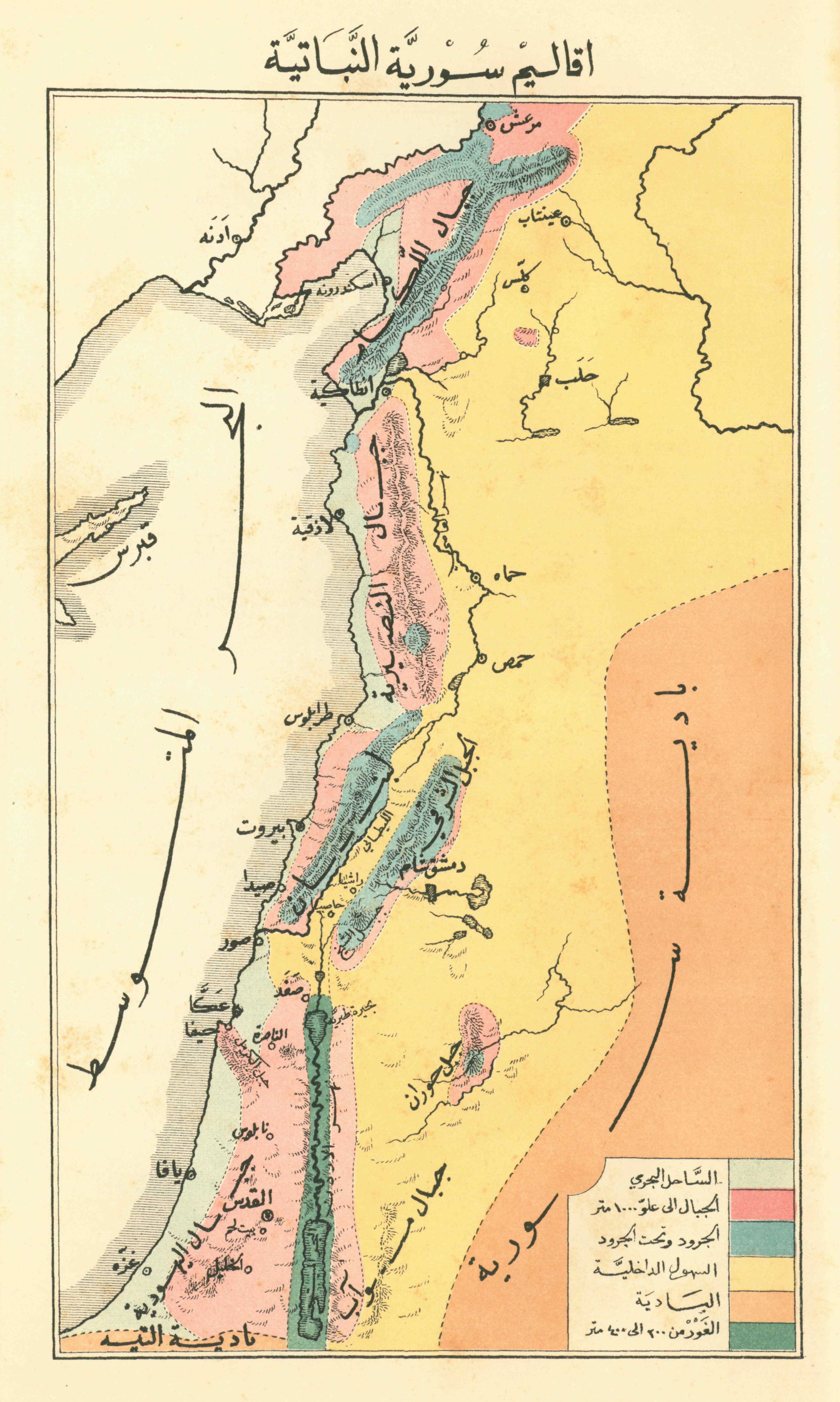
The final map in our collection comes from George Post’s Nabat Suriya wa-Filastin wa-al-Qatr al-Misri wa-Bawadiha (Beirut, n.p., 1884), 411 (The Flora of Syria, Palestine, and the Egyptian Country and its Desert).  The title of the map itself is: The Botanical Climate of Syria (Aqalim Suriyya al-Nabatiyya). Note that Filastin does not appear anywhere on the map.  Again, insofar as this is a translation of a book by one of most well-regarded botanists and geographers of Palestine in the nineteenth century, we once again see just how much the Arabs, in this case, came under the influence of their European counterparts.  Indeed, this is one of the first books ever published in the Arab language which included the word ‘Filastin’ in the title of the work, and, low and behold, it is a translation from the English! 

The editors of the OHP have urged me to include a cautionary note to nationalist ideologues on all sides of the spectrum:  the 'idea' of palestine in Arab and Ottoman thinking indeed bears heavy European influences, but this a point of scholarly interest, and has no political implications of any kind.  Nationalists love to point to the 'indigenousness' of their own nations and national territories -- their originality, their time-immemorialness.  But this 'urge' to 'defend' the 'taintlessness' (as if being influenced by Europeans is somehow 'tainted') of their own national spaces, to claim they were not 'mere' 'knee-jerk' 'reactions' to European ideas is itself profoundly reactionary, and embraces everything wrong with nationalism: its claims to ethnic or ideational purity; its ideas of exclusivity, gloriousness and ever-lasting-ness: these are dangerous ideas and have been at the origins of some of the most deadly and dangerous plots in all of human history.  Yes, Europe came to dominate the globe in the nineteenth century, with their bibles, guns and MAPS.


[1] This would be The David Rumsey Collection. 
[2] For a more detailed discussion of the pamphlet, See Salim Tamari’s, “Shifting Ottoman Conceptions of Palestine: Part 1: Filistin Risalesi and the two Jamals,” Jerusalem Quarterly 2011(47)
[3] Gideon Biger, “Where was Palestine? Pre-World War I perception, AREA” Journal of the Institute of British Geographers 13(2)(1981): 153–160.
[4] See, for instance, Sabri Sharif Abd al-Hadi Jughrafiyat Suriyya wa Filastin al-Tabi‘iyya (Cairo: al-Maktaba al-Ahliyya, 1923), 32; Butrus al-Bustani, Da’irat al-Mar‘arif 10 (1898), 196; Yehoshua Porath, “The Political Awakening of the Palestinian Arabs and their Leadership Towards the End of the Ottoman Period,” in Studies on Palestine During the Ottoman Period, Moshe Ma‘oz (ed.) (Jerusalem: The Magness, Press, 1986), 351-381; Johann Büsso, Hamidian Palestine: Politics and Society in the District of Jerusalem 1872-1908 (Leiden; Boston : Brill, 2011), 479.

Saturday, July 27, 2013

Beer Map


This map, by Feòrag NicBhrìde, has been floating around the internet for a while. Patrick Adamiak sent it along with the suggestion that perhaps it revealed something about the role of Ottoman history in the Balkans' linguistic development:

"You can almost visualize the 19th century borders of the Ottoman Empire in this map of all the terms for beer in Europe. With this map you can almost chart the time and place beer came to the Ottoman Empire; probably from their western Mediterranean neighbors, at a time when (at least parts of) Romania, Bulgaria, Albania, and Greece were still in the empire. Probably sometime in the 19th century, but definitely before 1878. you would expect Macedonia and Bosnia to follow this trend, but they use the general Slavic term instead. This suggests that Yugoslavia imposed the Slavic form of the word, or that beer spread from Slavic speaking Austro-Hungarian Croatia and Slovenia instead of from their Balkan neighbors to the south.

Some research bears this out.

It seems beer first came to the region when the new Bavarian king of Greece, Otto, brought a personal brewer with him in the 1830's. The brewer's son, who in 1864 founded the first commercial brewery in Athens, spent a lot of time exporting his products to the Hellenic state's neighbors. It seems that these brewers got people in the southern Balkans and western Anatolia to develop a taste for beer, and further German, Swiss, and Austro-Hungarian immigrants found an opportunity to open commercial breweries in Bulgaria, Romania, and Istanbul in the late 19th century. It is interesting, however, that despite the central European roots of beer production in the Balkans and western Anatolia, all these countries use the Italian form of the word Beer, Bira. Beer only came to be commercially produced in Italy from around the 1840's or so. It looks like the Ottoman and post-Ottoman world's longstanding commercial ties to Italy caused Bira to enter the various Ottoman languages from Italian before commercial, indigenous production started, even though the first wave of breweries were almost all started by enterprising central European immigrants who would've called it bier."

Lest we as the editors be accused of not contributing any real research to this post, here is a fantastic beer ad put out by the Turkish government that appeared in several magazines during the 40s. It features an image of a Hittite man serving beer, above a reminder that, as proven by recent excavations, "The beer you drink today has a 7,000 year history." Barely visible in the three circles below are the words "It Nourishes[Besler]" "It Refresher [Serinletir]" and "It Gives Joy [Neşe Verir]."


Sunday, July 21, 2013

From the Collection of Ibrahim Hakki Konyalı

Nick Danforth, Georgetown University

We are taking a break from maps to put up some assorted photos from the collection of Ibrahim Hakki Konyalı. A leading popular historian whose work appeared in countless newspapers and magazines from the 1930s through the 1970s, Konyalı also played a crucial role in helping preserve evidence of the Ottoman past. He intervened to prevent archival documents from being sold as scrap while working for the Turkish Military Museum and boasted, in the pages of the short-lived religious paper Büyük Doğu that he stopped the government from tearing down Ayasofya's minarets by claiming they were integral to the structural integrity of the dome. Konyalı briefly published his own magazine, Tarih Hazinesi, in the early 50s, promoting a conservative take on the recent past that blended religious nationalism with criticism of the Republican People's Party and its one party regime. A committed researcher and accomplished scholar, he also carried out a number of heated arguments with other historians who questioned his methods and his politics. Among other controversial revelations, for example, was a document in which Fatih Sultan Mehmet II put a curse on anyone who might violate his wish that Ayasofya remain a mosque for all eternity.

Today, Konyalı's papers are housed in a pleasant library next to the Selimiye Mosque in Uskudar, where the staff encourages researchers to pour themselves tea, or else brings it to you themselves along with the documents. Alongside article clippings and numerous notes (unfortunately often written in an illegible ottoman scrawl), Konyalı amassed a number of photographs of historic buildings, people and events. Here are six or seven of the more intriguing ones, to be followed by some other collections of his on subjects such as Mevlevi leaders and the Hicaz Railway. In most cases the captions are taken directly from his notes on the back of the photo, with additional information included when available.

"One of Istanbul's first taxis, a Ford, and its driver, Pangaltılı Apik" (Konyalı Archive, 679)


"Sabiha Sultan on the day of her wedding, 1921" Sabiha was the daughter of the last Sultan Vahdettin. Ataturk, among others, proposed to her after the end of the Gallipoli campaign. Somewhat later, of course, he would send her family into exile. Following stays in France and Switzerland, Sabiha ended up in Egypt for a while before returning to Turkey when allowed back in 1952. (Konyalı Archive, 202)


Hıdırellez celebrations (Ruz-ı Hızır or Hızır günü) in Ereğli [undated] (Konyalı Archive, 2907)


A monument to Muslim soldiers in the French army who died during the occupation of Istanbul
 after WWI. It is located in a cemetery near Topkapı outside of the city walls. (Konyalı Archive)


A "People's alcohol" factory in Konay, undated. The first two words of the sign read "Halk isprito." The image in the archive was a negative. Here it is with the color reversed. (Konyalı Archive, 893)


"Greek Prime Minister Karamanlis's house in Karaman" (Konyalı Archive, 1887) An interesting article in Hurriyet in fact cites Konayli's work as the source of the persistent rumor that the famous Greek politician Konstantin Karamanlis was in fact from Karaman in Turkey. In fact, Konstantin, whose nephew Kostas served as Prime Minister more recently, was born in northern Greece near Serres in 1907 when the region was still under Ottoman control. The article also mentions a conversation that supposedly took place in the 50s between Karamanlis and Adnan Menderes in which both prime ministers discussed the irony of the fact that Karamanlis took his name from the Turkish place and Menderes took his from an ancient Greek river.


"Greek prisoners working under the orders of the Cayhat Menzil Command on the Western Front" (Konyalı Archive, 752)


Wednesday, July 17, 2013

Malaria Map of Italy


Source: Sıhhiye Mecmuası, Vol 1 No 3 - Lucien Renault - "Italya'da sıtma mucadelesi" (1922)

Malaria, a disease that has been endemic to Mediterranean climates for perhaps millennia, was once known as the Roman fever. The marshes around the city of Rome did indeed prove fertile breeding ground for mosquitoes, the animal discovered to be the vector of the disease in 1900. Following the First World War, Italy became one of the principle centers of malaria research in the world as it embarked on a campaign to eliminate the disease, and countries with similar geographies such as Turkey looked to Italy as an example of how to combat malaria through a combination of swamp drainage, anti-malaria medications, and pesticides.


This map comes as a translated article in the Turkish medical journal Sıhhiye Mecmuası documenting the early-goings of Italy's battle with malaria. It is telling that Turkish scientists would be interested in translating such articles as they eagerly awaited the results of this unprecedented attempt to not just limit but eliminate malaria within the national boundaries of Italy.

The black areas represent official malaria control areas declared as part of these efforts in 1922. What they reveal is not entirely surprising. The low-elevation coastal areas of Italy were the principal areas where malaria was a threat. However, while the poorer and warmer south of the country was a natural area of focus for the fight against malaria, this map is a reminder that during the 1920s, malaria was still an issue in parts of the richer north near Milan and Venice and even surrounding the captial of Rome. 

The second map at right is a more detailed look at the different medical institutions associated with combating malaria in the Roma province (click here for a full-sized version)


Monday, July 15, 2013

The Uprising of Women in the Arab World
انتفاضة المرأة في العالم العربي


Here is another more contemporary map we encountered as graffiti on a wall in downtown Beirut representing the Arab World as the hair of a woman. It is the symbol of the group called "The Uprising of Women in the Arab World" or انتفاضة المرأة في العالم العربي in Arabic.

The group unites activists throughout the Arab world and began in 2011 with the political mobilization of the Arab Spring. Its Facebook group has over 100,000 members. The group's description is as follows on the English side of their website:

"It was an urgent reaction to the social and political developments in the region because we didn’t want the Arab Spring to be aborted. From Tunis to Egypt to Libya to Syria to Yemen to Bahrain…, the Arab revolts are led in the name of dignity, justice and freedom, but we cannot reach for those values if women are being ignored or absented from the main scenery.
United under the slogan “Together for free, independent and fearless women in the Arab world!”, the demands of the Uprising of Women in the Arab World are:
- Absolute freedom of thought, of expression, of belief or disbelief, of movement, of body, of clothing, of lodging, of decision making, of marriage or non-marriage;
- The right to autonomy, to education, to work, to divorce, to inheritance, to vote, to eligibility, to administrate, to ownership and to full citizenship;
- Familial, social, political and economical absolute equality with men;
- The abolishment of all laws, practices and fatwas violating the Universal Declaration of Human Rights, such as excision, stoning, lashing, the laws acquitting rapists or tolerating crimes of “honor”;
- Protection against domestic violence, sexual harassment and all forms of physical and psychological abuse and discrimination facing women today in the Arab world and beyond.
The campaign of the Uprising of Women in the Arab World aims to:
1- Highlight the various kinds of discrimination against women in the Arab world (social, economical, political, judiciary…). Being aware of the injustice we are subject to is the first step to counter it.
2- Pin out the fact that women in our region share many struggles. We could then create a common ground for feminist activism, overcoming the borders of the states and building on from each other’s experiences.
3- Re-open the debate in the social media on women’s conditions, especially that women have suffered lots of attacks after the success of the revolts of the Arab Spring countries.
The revolutions that made our heart pound and filled us with hope for each and every Arab country while getting rid of dictatorships must continue. We must now get rid of patriarchy that authorizes each man to be a dictator, whether with his sister, girlfriend, wife, daughter, or even his own mother… We, women and men together, must continue revolting against oppression and put forward our feminist demands. We will not accept any priorities imposed on us, we will not practice self-censorship and we will not compromise on our rights.
Let the Arab Spring continue until it does with women what spring does with the cherry trees."

Thursday, July 11, 2013

The Croissant of Crisis

Nick Danforth, Georgetown University


These are a few of the highlights from a French book of maps about the Middle East that came out in 1993 titled Atlas Geopolitique du Moyen-Orient Et Du Monde Arabe (edited by Philippe Lemarchand and published by Editions Complexe). Subtitled "Le Croissant Des Crisis" or "the Croissant of Crisis," the book examines the politics, religion, culture and history of the region through a post Gulf War lens. The result is a series of maps that are, by turns, informative, problematic, absurd and obscure. Included here are some of the highlights. The mapabove, for example, ranks Islamic countries according to the "severity" of their Islam, resulting in a graphic that, like so many others, seems to offer a seemingly precise rendering of already widespread impressions (Saudi Arabia and Iran are both super Muslim!) without offering any profoundly new insights (in Egypt, the situation is mixed. That certainly explains the last week or so!).

More helpful is the map below, which offers a handy guide to all the region's coups over the last half century. The next step, it seems, would be color-coding them according to whether the French or the Americans were responsible.


Finally, an interesting look at the linguistic development of the region, where English and French are facing off with Arabic and one another in an ongoing battle for cultural cache.


Monday, July 8, 2013

The New Assyria

From The New Assyria newspaper, October 15, 1916. For a full-sized image click here.

Despite their obvious idiocy, all sorts of ridiculous maps offering alternative visions of middle eastern borders show up everywhere online, spawning thousands of conspiracy theories and stealing attention from other, more interesting visions (like Lawrence of Arabia's). Maps of a reconfigured Middle East remain popular, it seems, because many people are convinced by the - I would argue questionable - idea that poorly drawn imperial boundaries are to blame for the region's problems. 

So at the risk of starting a whole new set of conspiracy theories, I'm excited to share this map from our go-to Suryani expert Benjamin Trigona-Harany. It's another rarely-seen vision for a completely different set of Middle East borders from 1916: The New Assyria. As Ben says "I've always liked this map because it signals that the adoption of a shared ethnic Assyrian identity by the Chaldeans, Nestorians and Süryani was in full swing - not to mention showing their charmingly optimistic borders for a future Assyrian state."

After I admitted that my understanding of the groups in question was limited to the assumption that Nestorians were followers of the Nestorian Heresy (and probably don't call it that), Ben was kind enough to explain:

"The Chaldeans are Nestorians who joined the Catholic Church. What became the Süryani are one of the groups that rejected the Council of Chalcedon (Kadıköy) for being too conciliatory to the Nestorian position. The others that joined them were the Copts/Ethopians and Armenians. There is also a Catholic offshoot of the Süryani church with its own Patriarch. All of them use Syriac, a dialect of Aramaic, as a liturgical language, and modern variants are still spoken by a few communities today.

We can say that today, all Nestorians, most Chaldeans and many Syriacs (meaning Süryani) consider themselves descendants of the ancient Assyrians. A small minority of Chaldeans think they are actual Chaldeans, and perhaps half of all Syriacs self-identify as Aramaeans.

Whatever the ethnicity actually is (and I have no dog in that fight), the pre-20th century Syriacs didn't consider themselves to be part of any greater Assyrian community, although a new wave of nationalist historiography centres around proving a continuous Assyrian identity whereas it used to be about proving the ancestral bonds between the modern and ancient Assyrians.

The emergence of a greater Assyrian community coincided with the early twentieth-century diasporas, particularly in the United States, and was then reinforced by the arrival of World War I survivors. You don't find an Arab identity like you do in the Maronites (who are also claimed by Assyrian nationalists) or the Levantine Greek Orthodox and Melkites.

This map reinforces this maximal claim of an ethnic bond between these different peoples more than it delineates the borders of a future state, and that is what makes this map interesting to me. A few years after the appearance of this map, the Assyrian delegation at the Paris Peace Conference did float the idea for an Assyrian state about half the size of the one you see here; still unrealistic but more representative of Nestorian, Chaldean and Syriac settlement."

Friday, July 5, 2013

Cheese Map


Several years ago I got a ride from a truck driver who worked for an Edirne-based cheese factory and told me that Turkey had over 330 kinds of cheese. At the time I was niave enough to think that this must be a wild exaggeration, or at least an absurdly optimistic way of tallying minor variations in beyaz peynir. Now I know better. This map, from Artun Ünsal's excellent book Süt Uyuyunca [While Cheese Sleeps] provides a comprehensive overview of Turkey's regional cheeses.