


Today's post comes out of my effort to make the case that the Iraqi-Syrian border is an odd place from which to claim the end of the the Sykes-Picot treaty and the Middle East state system it created. Among other things, the French and British imperialists behind Sykes-Picot apparently cared so little about the stretch of border that the ISIS has over-run that they didn't bother demarcating it for about a decade, and even then were sufficiently indifferent that they let the League of Nations arbitrate their conflicting claims.
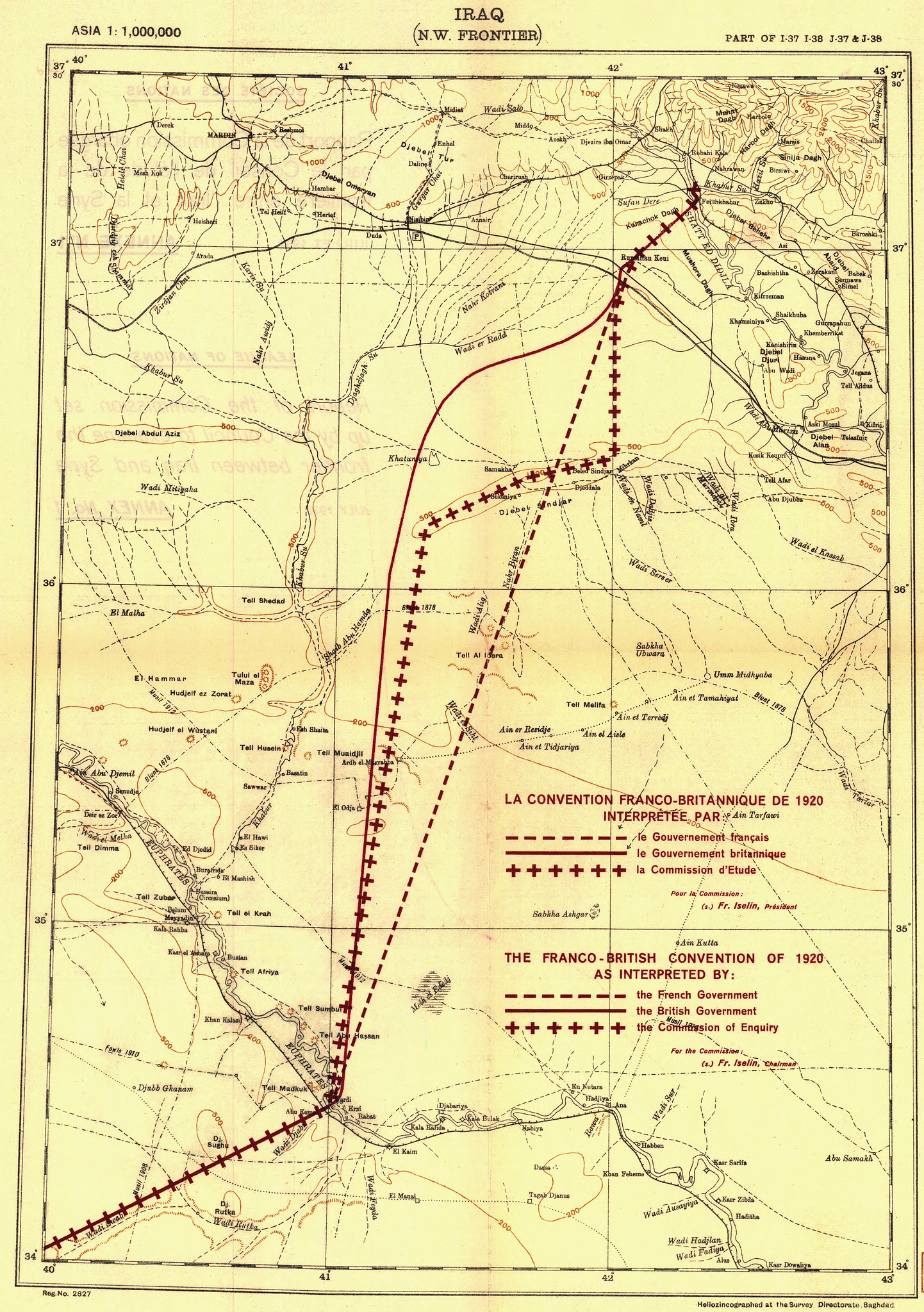
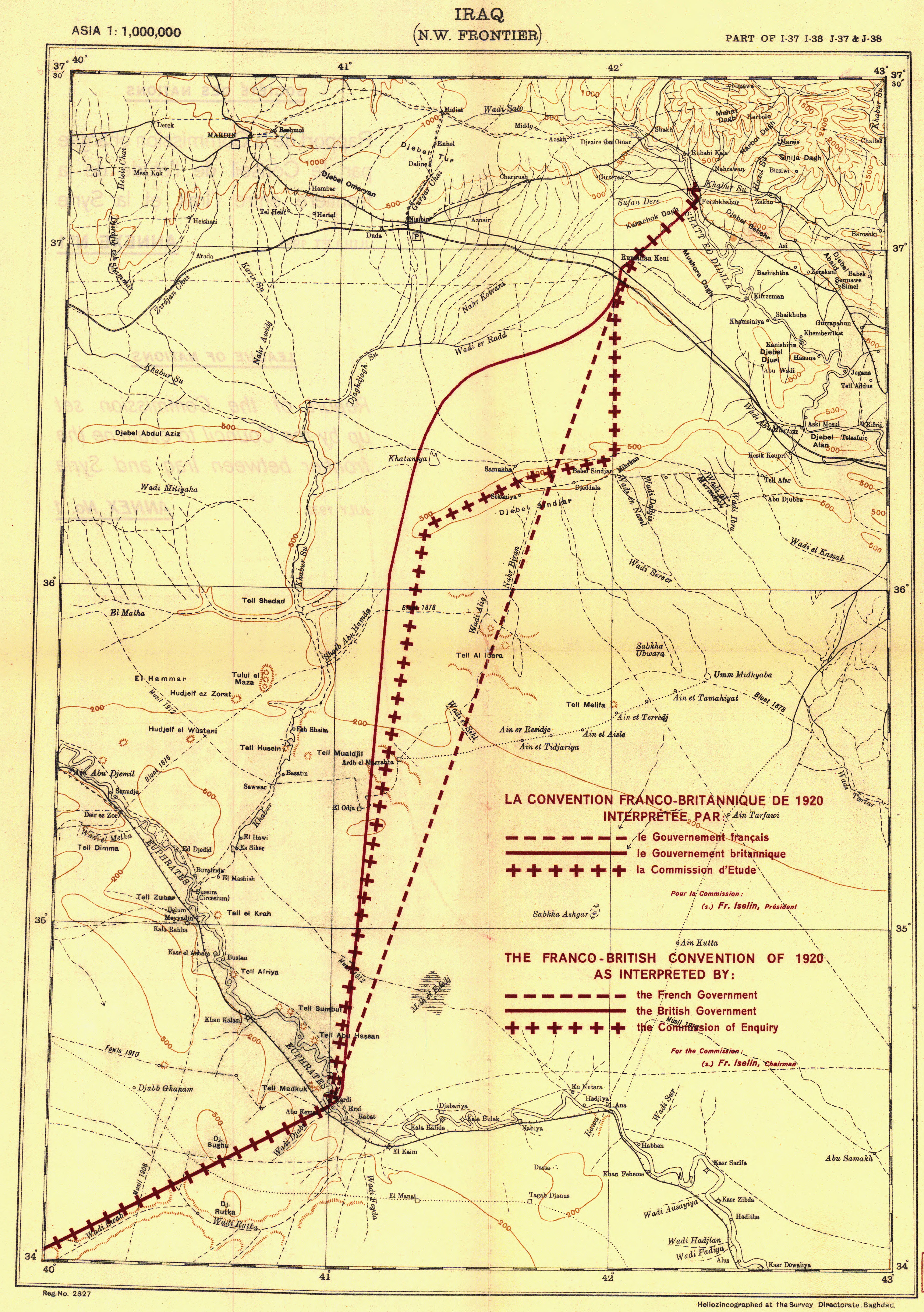
The map above shows the work of a League Commission assigned to arbitrate between rival interpretations of the border's path between the Tigris an Euphrates Rivers. (click here for a close up of the map, courtesy of the Rumsey collection). A 1970 report from the US state department offers the step by step written narrative of the commission's decision. As the report explains:
The Convention, which defined the boundaries of Iraq and Syria, is titled, the Franco-British Convention of December 23, 1920, on certain points connected with the Mandates for Syria and the Lebanon, Palestine, and Mesopotamia. It provided for the demarcation of the frontiers by an Anglo-French Boundary Commission but delimited the boundary only in general terms, subject to later determination. On February 3, 1922, the two powers signed another agreement which differed only slightly from the original delimitation. The boundary as it is today is based on the League of Nations Report of the Commission entrusted by the Council with the study of the Frontier between Syria and Iraq, Geneva, September 10, 1932.
 |
| The Sinjar Sector, from Google Earth |
1. Tigris-Sinjar Sector From the confluence of the Eastern Kabur and the Tigris, the thalweg of the Tigris to about one kilometre below Pesh Kabur; thence a straight line to Tell Dahraya (point 384); thence a straight line as far as Tell Khoda-ed-Deir (point 391).
2. Sinjar Sector Majority Proposal.From Tell Khoda-ed-Deir (Point 391), a straight line to Tell Rhuli (trigonometrical point 402); thence to trig. pt. 645; thence to trig. pt. 573; thence to trig. pt. 395, and terminating at Tell Sfug (trig. pt. 332).
3. Salt-deposit Sector
From Tell Sfug (trig. pt. 332) in a straight line to trigonometrical point 331; thence to trig. pt. 280; thence to trig. pt. 259; thence to trig. pt. 276; thence to trig. pt. 230; thence to trig. pt. 236; thence to trig. pt. 231; thence to the ruins of the small military post on the border of the Buara salt deposit (point 164, 3.6 kilometres W.N.W. of trig. pt. 172); thence to trig. pt. 167; thence to El Gara (trig. pt. 193); thence to trig. pt. 174; thence to the Jebel Baghuz (trig. pt. L.S. 29, not indicated on the map).
4. Euphrates Sector
 |
| And a slightly greener picture |
5. Euphrates-Jebel Tenf Sector
From the Leachman boundary-stone in a straight line to the point situated 30 kilometres from the minaret of Abu Kemal on the straight line joining that minaret to the point situated 3.2 kilometres north of Tell Romah; thence this latter line as far as its intersection with the frontier between Iraq and Transjordan.15
The State Dept. report concludes by noting that the Commission also included a minority report more favorable to French interests that was rejected by the League. This proposal "followed a line southeastward from Tell Rhuli, through a pass in the Jabal Sinjar, referred as "Bab-ech-Chilu," then to Tell Yusef Beg, then in a straight line rejoining the majority proposed line at "Tell Sfug." The League, in a token gesture of fulfilling the stated mission of the Mandates, decided that the French version would have meant splitting the Jabal Sinjar, where "most of the Yazidi people lived."