


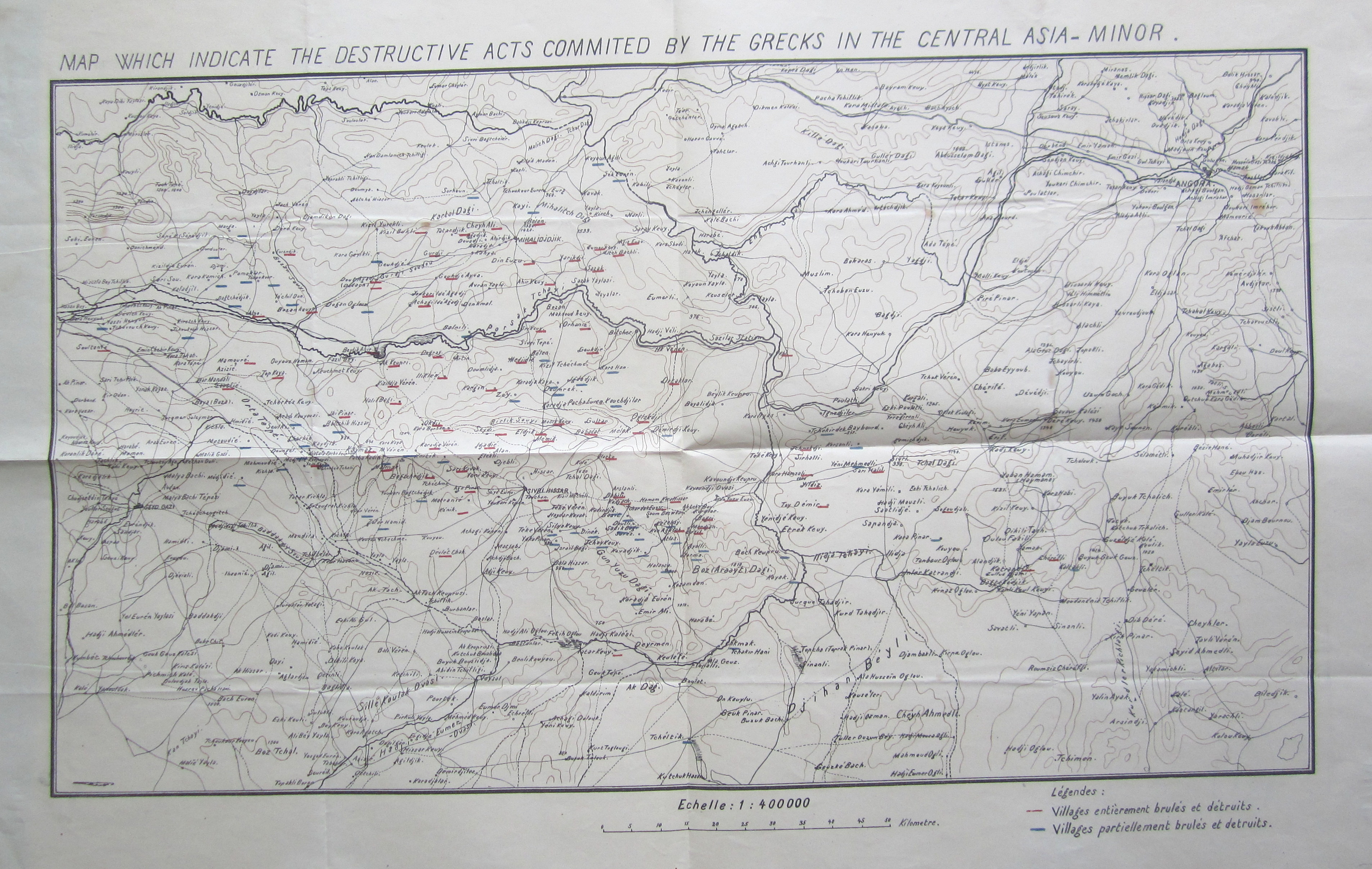
"Map Which Indicate the Destructive Acts Commited by the Grecks in the Central Asia Minor" (Source: BOA, MF-VRK 21/124)
click for full-sized image or click here for Ottoman Turkish version (Source: BOA, MF-VRK 51/75)
 |
| Burnt Locomotive Near Uşak following Greek withdrawal from Anatolia, 1923 Source: Albert Kahn Collection |
The depredations of the Greek army during the Allied invasion of Anatolia following World War I and the nationalist resistance to the occupation are an essential part of the Turkish national narrative. Villages and towns destroyed by fleeing Greek armies symbolize the gravity of a "life and death struggle," as the the independence war is commonly remembered. To point out that this historical experience has been wielded as a discursive tool in the making of a modern Turkish nation state is not to deny the validity of this experience but to understand how collective memory of certain events is formed. Indeed, the following maps can be used to understand localized destruction during the war, bearing in mind that it does not include destruction caused by the Ottoman/Turkish armies, but they also can be used to understand the formation of national consciousness in Anatolia during the war period.
These maps appeared in the files of the education ministry, meaning that they were intended for a certain didactic function. The above map, which is available in numerous copies both English and Ottoman in different boxes from the national struggle period attempts to show village by village areas destroyed or partially destroyed by the Greek army underlined in red and blue respectively. I compared the numerous copies of the map that I found and all are consistent in their representation of which villages had been destroyed and to what extent. That it survives in so many copies and that it was published in both English and Ottoman Turkish emphasizes how the nationalist narrative was being deployed through maps and education in the very moment that these events were unfolding.
 |
| Source: BOA, MF-VRK 51/75 |
This was occurring through the use of a number of maps including the one at right of Central Anatolia that on the whole resembles the first (Source: BOA, MF-VRK 51/75)
Finally, the third map I have placed here (click for full sized image) of the Kocaeli region is taken from an issue of the newspaper Vakit found in the education ministry's files (likely because the paper ran a story on the new education minister). The map, which accompanied an article about the ongoing fighting, served to situate the war in a detailed geographical context. Readers might also enjoy the cast of historical figures from the period that adorned the front page of this newspaper.
 |
| Source: Vakit, August 23, 1921 found in BOA, MF-VRK 50/33 |