Showing posts with label Destroyed Villages. Show all posts

Saturday, April 19, 2014

3 Maps of an Armenian Town that Exists No More

Chris Gratien, Georgetown University
In October of 1920, Turkish nationalist militias took control of a town called Hadjin (Turkish, Hacın / Armenian, Հաճըն) located north of Adana in the Taurus Mountains. Of the thousands of Armenian inhabitants who had survived the genocide during the war years (1914-1918) to return to their town with the arrival of the French occupation, many were killed and the remainder fled during an eight-month siege. As the French military withdrew from the Adana region not long after, the Armenian population went with them, ultimately joining diaspora communities in Syria, Lebanon, France, the Soviet Union and the Americas.

The story of Hadjin resembles that of many other Anatolian towns with large Armenian communities during the last years of the Ottoman period. Whereas Hadjin boasted a population of some 30,000 before the war, more than half of whom were Armenian, the town of Saimbeyli located in the former site of Hadjin today is considerably smaller. Most of the physical traces of Armenian life in the area have been erased. Meanwhile, a village in modern-day Armenia called Nor Hachen or "New Hadjin" stands as a small memorial to what one descendent of Hadjin's inhabitants referred to as "a town no more."

Members of the Armenian diaspora communities conscious of the fact that their natal villages might someday be wiped from the historical memory sought to compile information about the history and social life of towns such as Hadjin in exhaustive histories usually composed in Armenian. One such work about Hadjin was published at a fairly early date in 1942, just two decades after the French withdrawal, meaning that many who had experienced the town as adults were able to contribute. Only a few copies of The Complete History of Hadjin (H. P. Poghosean, Hachěni ěndhanur patmutʻiwně ew shrjankay gōzan-taghi giwgherě) were published, most of which were in the possession of contributors, donors, and families from the Hadjintsi community. Some eventually made their way into university libraries.

These three hand-drawn maps (composed in Los Angeles during the 1940s) are scanned from one such copy. They offer exquisite geographic detail about a world that no longer exists. The first (see above) displays Hadjin and its immediate vicinity with complete labels of adjacent villages, monasteries, fortresses, rivers, forests, yaylas, and mountain peaks. Hadjin, which sat at more than 1km above sea level, was protected on three sides by mountains, which explains the endurance of local resistance to the Kemalist advance in 1920 as well as the town's defense from harm during the Adana massacre of 1909.

The second map offers a detailed layout of Hadjin during the late Ottoman period. Such an intimate view of a small Anatolian town from that time is considerably rare, given that detailed maps were not often produced.

Wednesday, February 6, 2013

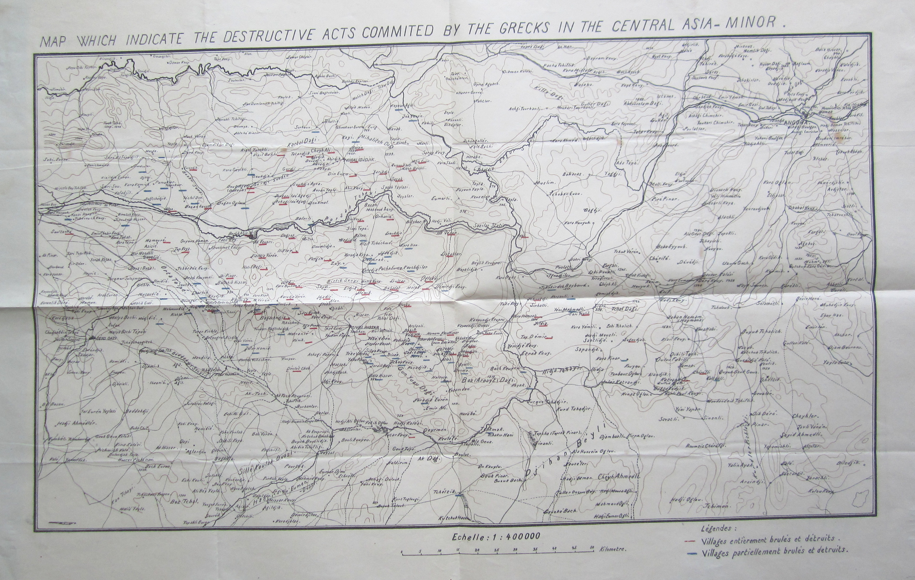
What the Greeks Destroyed: Early Maps of the Turkish National Struggle


"Map Which Indicate the Destructive Acts Commited by the Grecks in the Central Asia Minor" (Source: BOA, MF-VRK 21/124)   


Burnt Locomotive Near Uşak
following Greek withdrawal from
Anatolia, 1923
Source: Albert Kahn Collection
The depredations of the Greek army during the Allied invasion of Anatolia following World War I and the nationalist resistance to the occupation are an essential part of the Turkish national narrative. Villages and towns destroyed by fleeing Greek armies symbolize the gravity of a "life and death struggle," as the the independence war is commonly remembered. To point out that this historical experience has been wielded as a discursive tool in the making of a modern Turkish nation state is not to deny the validity of this experience but to understand how collective memory of certain events is formed. Indeed, the following maps can be used to understand localized destruction during the war, bearing in mind that it does not include destruction caused by the Ottoman/Turkish armies, but they also can be used to understand the formation of national consciousness in Anatolia during the war period.

These maps appeared in the files of the education ministry, meaning that they were intended for a certain didactic function. The above map, which is available in numerous copies both English and Ottoman in different boxes from the national struggle period attempts to show village by village areas destroyed or partially destroyed by the Greek army underlined in red and blue respectively. I compared the numerous copies of the map that I found and all are consistent in their representation of which villages had been destroyed and to what extent. That it survives in so many copies and that it was published in both English and Ottoman Turkish emphasizes how the nationalist narrative was being deployed through maps and education in the very moment that these events were unfolding.

Source: BOA, MF-VRK 51/75
This was occurring through the use of a number of maps including the one at right of Central Anatolia that on the whole resembles the first (Source: BOA, MF-VRK 51/75)

Finally, the third map I have placed here (click for full sized image) of the Kocaeli region is taken from an issue of the newspaper Vakit found in the education ministry's files (likely because the paper ran a story on the new education minister). The map, which accompanied an article about the ongoing fighting, served to situate the war in a detailed geographical context. Readers might also enjoy the cast of historical figures from the period that adorned the front page of this newspaper.

Source: Vakit, August 23, 1921 found in BOA, MF-VRK 50/33