Wednesday, February 27, 2013

Plane Routes

Were excited to post the first of a number of fantastic maps that Kerim Bayer has been kind enough to share with us. There will be more of these to come, and hopefully at some point soon Kerim will have a website of his own where people can enjoy the full extent of his collection online. 


Flight Route Maps from an Early Republican Atlas: for a full sized image with maps of Asia Australia and South America too click here

Following up on all our earlier maps on train routes, it's strange to remember that at one point planes had routes too. They still do, of course, but now the actual flight path seems a little beside the point. In-flight magazine maps show all those looping lines connecting cities with no regard for how the plane actually travels between them. The precise paths of an earlier era are now mostly familiar to us from Indiana Jones movies. Among other things, this map, from an early Republican atlas, also shows some continuing trouble with US geography. They seem to have first placed Chicago somewhere in Nebraska before relocating it and renaming that town Omaha. Other transliterations include Detruvat (MI), Harlston (SC) and Key Vest, on the way to Havana.


Europe

Tuesday, February 26, 2013

Alexander's Conquests


An Ottoman historical map showing Alexander the Great's route and conquests. Regions not directly conquered but under his authority are yellow, regions that are not are in pink. Nothing profound to say about this map either, except that it still seems fantastic that the Islamic world calls him Iskender because the Al in Alexander was an article. Sort of the opposite of how English got Alligator from the spanish el lagarto.

Wednesday, February 20, 2013

Ottoman Food Map

Nick Danforth, Georgetown University

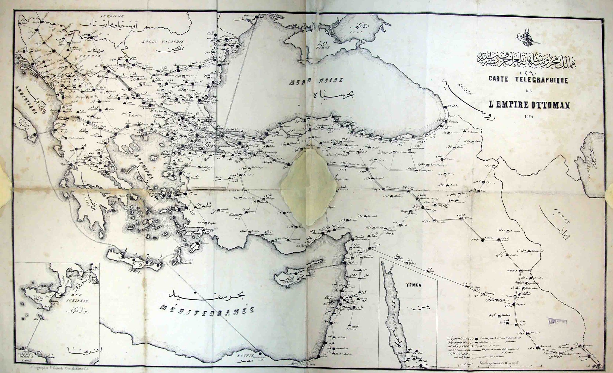
After presenting a number of other people's beautifully drawn maps, I am excited to put up a crudely drawn one of my own. This map shows where foods that, in America, are generally thought of as generically Middle Eastern or Mediterranean are commonly consumed. A more detailed mapping of each of these foods can be found at ottomanfoodmap.com. A nicer version, done by a real cartographer appears in the recently published Food: an Atlas. In any case...

"Lebanese and later Greek immigrants brought a number of unique dishes to America, where they gradually cohered into a unified cusine. As our maps show, these foods do indeed span a wide region, crossing religious, national and linguistic boundaries. Yet they also define unique culinary, cultural and geographic regions. The practice of drinking strong coffee in small cups with grounds, for example, reaches from the Balkans all the way to North Africa. Hummus, though, is relatively rare in Greece and Turkey. Like fallafel, its northern limit is strangely co-terminus with that of the Arabic language. Distilled liquor flavored with anise is drunk under a variety of names - Ouzo, Raki, Arak - across the region. In the Balkans, however, Raki refers to a different, more popular drink that more closely resembles Grappa or paint thinner. Yogurt is not even featured, being almost inescapable in the region (as if to illustrate this whole phenomenon, it has come to our attention that the founder of America's most popular Greek yogurt brand, Chobani, is of Turkish origin). The availability of octopus, not surprisingly, is limited by the unique geology of the Aegean sea. Ottoman Food Map allows readers to explore for themselves the geography of these foods, with a minimal degree of commentary and illustration. We have not dared to offer any speculation on national origins, nor have we tried to map the spread of cultural tendencies, like the mustache, that are universal."

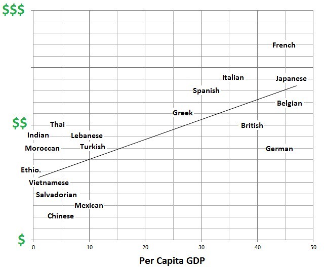
On a related note, I will take this opportunity to share the result of a similarly unscientific study into the relative price of different cuisines (according to the top ten yelp reviews per cuisine in the DC area) versus the GDP of the countries those cuisines are associated with. The results are hardly surprising. Not only is there a general correlation, but at both ends of the spectrum some countries punch above their weight (France, Thailand) and others well below (Germany). Still, there is something troubling about seeing that, yes, the average meal at a British restaurant costs more than the average infinitely better meal at an Ethiopian one.

Interestingly, Turkey seems to making strides in the US food market in keeping with its rapidly growing economy, as well as its rising cultural capital. Turkish chefs have tried to create a gourmet kebab market to mirror the success of the gourmet hamburger market, present mezes as a form of Turkish tapas and pair village cheeses like Tulum with honey and fruit in pricey cheese plates.


Sunday, February 17, 2013

Treasure Maps


Anyone who has traveled in rural Turkey as a foreigner has undoubtedly had the experience of being taken for a spy. Most likely, anyone who has ever expressed interest in Greek or Armenian ruins has also had the experience of being asked, first jokingly, then with the offer of a 50/50 split, if they are there for the gold. Indeed, combing the countryside for buried treasure has long been a popular pursuit in Turkey, as documented in the brilliant Yilmaz Guney's inexplicably unwatchable film Umut (Hope). Sometimes finding it involves religious incantations, but often, especially in the East, it involves trying to piece together the meaning in religious symbols or Armenian letters carved into stones around graveyards or ruined churches. Countless websites, such as defineci.org or hazineavcisi.com, offer forums where users can discuss the meaning of these clues or ask for advice in interpreting local topography, as well as share found, photocopied, hand-drawn or annotated maps like these. Each letter or motif - a snake, a pair of birds, a cross, a cup, or anything else - can tell prospective treasure hunters which way to go, how many steps to take and how far down to go when they start their digging.

For the full post on Treasure Hunting and Kurdish-Armenian relations, complete with more maps, check out our article at The Tuqay, an excellent source for news from beyond the well protected domains.


Thursday, February 14, 2013

Braille War Map of Europe


Braille Map of Europe (Source: Bain News Agency, c1910-1915 - US Library of Congress): click here for a full-size map     

It's hard to find something profound to say about this braille map of Europe from World War I, but readers might be interested to know that the braille alphabet used in publications for the visually impaired actually developed out of the context of European warfare. Sonography, a system of writing using embossed dots on a piece of paper, was developed for use as a code for silent and nighttime communication in Napoleon's armies and later modified into the modern-day Braille alphabet by Louis Braille.


Wednesday, February 13, 2013

Urbanization in Turkey

Gecekondu Settlements
Calorie Intake of Urban Workers versus Farmers

For some reason people studying Turkey love explaining the word gecekondu. Using it, along with perhaps the phrase "deep state," is pretty much enough to qualify you as an expert on contemporary Turkish politics and culture. Anyways, we don't have any good maps of the deep state, but here is one of gecekondu growth in Istanbul in the 1950s, when Istanbul was a much smaller place. Wait, allow me to explain, as if you've never heard the word before: 'gecekondu' literally means a settlement that was built overnight, and refers to a law stating that any building finished by sunrise could not be torn down. Anyways, with the increasing mechanization of agricultural in this period, in part thanks to US aid, a number of people who had in the past worked as farmers were forced to move to the city in search of work, living in shanty towns that sprung up beyond what were then the city limits. Over time, competition for votes led Turkish politicians to woo these communities by bringing them electricity, water and other municipal services. As this map shows, many of these settlements have since been integrated into the fabric of the city, and are now simply neighborhoods rather than slums. Meanwhile, new ones have continued to spring up further out.

 The chart to the right, though not technically a map, nor technically about Turkey, does an incredible job of illustrating the effect of urbanization on people's lives all around the world during this period. Written in the kind of French that even I can read, it shows the average daily calorie intake of farmers versus urban workers throughout the year. For farmers, it follows a seasonal cycle, with nutrition levels reaching a low point in the dry summer months (this chart is from West Africa. In the northern hemisphere this low point would come at a different time, but the general pattern would be the same). Nutrition levels for urban workers follow this same pattern to a more muted degree, but for them the variation within a single pay-period is much more dramatic. The hungriest time for them is at the end of the month when financial rather than environmental factors restrict their eating. On one hand the switch to an industrialized economy has benefited urban workers by protecting them from the vicissitudes of the environment. On the other, the capitalist economy has exposed them to a new form of deprivation, which as the chart shows, was often just as bad if not worse.


Gecekondu Map: Imar ve Iskan Bakanligi Mesken Genel Mudurlugu Arastirma Dairesi 10, reprinted in Necati Sen's "Plan ve Yapi Bakimindan Gecekondularinin Incelenmesi."

Nutrition Chart: Rapport Sur La Situation Sociale Dans Le Monde, United Nations, New York, 1957

Monday, February 11, 2013

Europe at War


Europe at War: For a full size map click here

We are all used to seeing historical maps of Europe during World War Two that were drawn after the fact and therefore treat the changes wrought by the war as temporary. This map was printed in 1940, between the invasion of Poland and the invasion of France, and so it treats these changes as a fact of life. Germany is huge, Poland, Czechoslovakia, Austria and Moldova are gone, Istria and Albania are Italian, the tip of Slovakia is Hungarian and Finland has an outlet to the Arctic Sea. Historical maps of the war tend to focus on showing what was basically under German control versus what wasn't, but as Mark Mazower discusses in Hitler's Empire, the Germans actually gave some thought to redrawing borders according to their own political and nationalist logic. Ethnically German areas like the Sudetenland became part of Germany proper, while cooperative governments like Hungary's were rewarded with extra territory.

Faced with Germany on one side and Russia on the other, Turkey spent much of the war desperately trying to stay neutral. For once, the mapmakers seem delight to color all of Anatolia white, as if it was outside the mess Europe had become.

Sunday, February 10, 2013

Intellectuals Per Capita in Ottoman Anatolia

Nick Danforth, Georgetown University


In what was undoubtedly one of the most remarkable academic endeavors of 1940, Professor Dr. Sevket Aziz Kansu, the Dean of the Faculty of Languages, History and Geography at the University of Ankara, set out to tabulate and map the number of Ottoman intellectuals produced per capita in each of the major regions of Anatolia. He did so using 1927 census data, Bursali Mehmet Tahir's "Ottoman Authors," 906 index cards  - classified according to birthplace, and a set of 9 geographic regions that he just kind of made up. The surprising results, after the jump.

Thursday, February 7, 2013

Trains and Telegrams

Nick Danforth, Georgetown University


A classic map showing the Ottoman rail system on the eve of World War I, with dotted lines for the unbuilt segments. Ataturk once said that if they had finished the stretch through the Taurus mountains near Adana before the war, the outcome, at least in in their struggle with the British for control of the Middle East, might have been different. Interestingly, Benjamin Fortna points out in Imperial Classroom, Ottoman map-makers had taken to coloring Ottoman territory pink in their own maps, mimicking the color the Great Britain used for its empire. Needless to say there is no indication that Egypt is anything but an ordinary territory, and certainly not one that had been de facto independent for almost a century. It also shows Ankara at the end of the train spur going out to eastern Anatolia, which is a large part of what led to its selection as capital for the nationalist movement. Finally, the mix of old and new geographic terms is interesting. The core of what is now Iraq is labelled "Iraq," with the northern part labelled as al-Jazira, a geographical designation for the Upper Mesopotamia that has lost some currency now that the region is split between three different states. The desert to the west of Mesopotamia is the "Badiyat al-Sham" referring to the deserts and uncultivated regions of Syria, while the coastal area that includes what is now Syria, Lebanon and Israel is labelled "Syria." South of this is "Arabistan." "Egypt" is written across the Nile, with the desert beyond it described as "Libya." And Anatolia, which was once just the Western peninsular part of what is now Turkey, seems to be written so as to include everything we currently think of as being Anatolian.

It is interesting to compare the rail network to the telegraph network shown in this regrettably tattered, poor resolution and digitally cobbled together map from 1874.


The full black dots are stations capable of international transmissions, the black and white dots are those only available for domestic use. Similarly, the thick black lines are international, the thin ones domestic. I wish  I had something more profound to add here. If anyone else does please share.

Both maps are from the Ataturk Kitapligi. The first is Htr_Gec_00063. The second can be requested by its photograph numbers, DSCN5503 and DSCN5504.

Wednesday, February 6, 2013

Western life in the Eastern Mediterranean

A gift to passengers, 1955
Map of Beirut
The book on the left was given to Syrian Airways passengers in 1955. It contained historic and touristic information, as well as a number of maps which will appear in a future post.

The card on the right turned up in a history of Syria donated to the Islamic Research Center in Istanbul. The back was covered in hand-written phone numbers. The front shows all the important spots for a foreigner in Beirut during the heyday of Western influence. There's the French Ambassador's Residence and the British Ambassador's, the Shell station and the Mobile station, The Black Elephant and the Harlequin, Piquot St. and Clemenceau St, the waterfront hotel and the church. It doesn't show much else. The card, which may well have been part of an invitation to a diplomatic event, has no date, though Graham Pitts identified it as after World War II by spotting Spears St, named after the British general there during the war.

What the Greeks Destroyed: Early Maps of the Turkish National Struggle


"Map Which Indicate the Destructive Acts Commited by the Grecks in the Central Asia Minor" (Source: BOA, MF-VRK 21/124)   


Burnt Locomotive Near Uşak
following Greek withdrawal from
Anatolia, 1923
Source: Albert Kahn Collection
The depredations of the Greek army during the Allied invasion of Anatolia following World War I and the nationalist resistance to the occupation are an essential part of the Turkish national narrative. Villages and towns destroyed by fleeing Greek armies symbolize the gravity of a "life and death struggle," as the the independence war is commonly remembered. To point out that this historical experience has been wielded as a discursive tool in the making of a modern Turkish nation state is not to deny the validity of this experience but to understand how collective memory of certain events is formed. Indeed, the following maps can be used to understand localized destruction during the war, bearing in mind that it does not include destruction caused by the Ottoman/Turkish armies, but they also can be used to understand the formation of national consciousness in Anatolia during the war period.

These maps appeared in the files of the education ministry, meaning that they were intended for a certain didactic function. The above map, which is available in numerous copies both English and Ottoman in different boxes from the national struggle period attempts to show village by village areas destroyed or partially destroyed by the Greek army underlined in red and blue respectively. I compared the numerous copies of the map that I found and all are consistent in their representation of which villages had been destroyed and to what extent. That it survives in so many copies and that it was published in both English and Ottoman Turkish emphasizes how the nationalist narrative was being deployed through maps and education in the very moment that these events were unfolding.

Source: BOA, MF-VRK 51/75
This was occurring through the use of a number of maps including the one at right of Central Anatolia that on the whole resembles the first (Source: BOA, MF-VRK 51/75)

Finally, the third map I have placed here (click for full sized image) of the Kocaeli region is taken from an issue of the newspaper Vakit found in the education ministry's files (likely because the paper ran a story on the new education minister). The map, which accompanied an article about the ongoing fighting, served to situate the war in a detailed geographical context. Readers might also enjoy the cast of historical figures from the period that adorned the front page of this newspaper.

Source: Vakit, August 23, 1921 found in BOA, MF-VRK 50/33

Monday, February 4, 2013

Trams and Transport in Istanbul


Istanbul Tram Ticket: for a full sized image click here


Istanbul's first tram system was run as a concession by the French, hence the initials STC or Société Tramways de Constantinople. As the ticket above (issued for a one way trip to Besiktas) shows, it was fairly extensive, running all the way from Bebek in the north to Eyup and Yedikule in the old city (Vikipedia has a nice map of the different routes in French, along, with the Golden Horn labelled Corne D'or). A map from the early Republican period (left) shows much the same system, but of course with the names no longer written in French.

In the 1950s, many of the tram lines were torn up to make room for cars on the relatively narrow streets. The problems were quickly apparent, hence the following map (below) of Istanbul's transportation needs in 1958. It appears a vast majority of the city's movement then took place on a north-south axis from Şişli to Eminönü. (Another map shows the popularity of different ferry routes. Eminonu-Kadikoy was by far the most used, with virtually no one going to Üsküdar from Beşiktaş or elsewhere)

Sunday, February 3, 2013

Ottoman Map of North America


Ottoman Map of North America (Source: BOA, MF-VRK 49/25): for a full-sized image, click here    

Given that American students are not known for their knowledge of geography, even if this very late Ottoman (1919/1920) map of North America from the education ministry will seem an inadequate representation of the US and its neighbors, it might well do some good in today's classrooms at the very least as a historical document.

Map showing Russian
America, 1860s
Printed by Dalmatian immigrants and lithography pioneers of the Ottoman Empire Zellich & Sons, the map has its idiosyncrasies. Only a few cities such as New York, Boston, Philadelphia, Baltimore, and Washington are labeled on the East Coast. For the rest of the country, only Chicago (spelled Chigaco), New Orleans, and San Francisco merit mention. Of course, the US had far fewer cities during that period, but there is still a clear Ottoman-centrism reflected in the labeling of consulates (şehbenderlik) and the embassy that marks Washington, DC with a big Ottoman flag. This being said, it is worth noting the large number of consulates, which should be a reflection of the extent of migration to North America by communities from the Ottoman Empire during this period its commercial ties with the United States.

This representation is also not without its imperfections. The State of California is mislabeled as "Falifornia" and Mississippi looks more like "Mississippa," a forgivable error given dialectical variation. There appears to be an Ottoman consulate in Charleston based on the placement of the dot, though the city is not named. The naming of Alaska as "Russian America" is more anachronistic than entirely incorrect given that Alaska had by this time been a solidly American territory for over half a century. Likewise, the term New Britain from had fallen out of favor following the establishment of the Confederation of Canada in 1867. A less forgivable error might be labeling the Pacific Ocean as the Atlantic Ocean, creating the strange impression that the Americas are entirely surrounded by the Atlantic and therefore the rest of the world must not exist.

Yet, to return to my original point about American students, I must admit that I learned a thing or two about the geography of North America from this map, namely that the Colorado River is actually in Texas.

Russian America
Map Key
Mexico
East Coast Cities

At the Gates of Vienna


The Turks' hasty retreat from Vienna in 1683 has always been seen as one of the Great Turning Points in history, as if to suggest that if only the Turks had succeeded, they could have kept going all the way to Paris. More likely, they would have been forced to retreat after a little while anyways, and Vienna would have a couple crumbling mosques that no one visits. In any case, these maps show the Turkish siege as it looked then, and as it would look mapped onto the urban fabric of modern Vienna. These are from Cevat Ustun's "1683 Vienna Campaign" although enthusiasts of  mid-twentieth century Turkish military history might prefer M. Sevki Yazman's "Return from the Gates of Vienna." Yazman relates that as an Ottoman soldier fighting with the Austrians on the Gallicean front in World War One he often went to Vienna when on leave. Naturally, he didn't think much about history, for he was a young man and knew that he could die any day. One night, after a lengthy dinner he began to feel that if he drank another glass of wine he would be unwell, and asked his Austrian friend if he could find a cup of strong, unsweetened coffee somewhere. His friend laughed. "Can it be that a Turk, whose people brought coffee not just to this city but to all of Europe, has never tried it here?" The friend went on to explain how when the Turks retreated in haste they left behind sacks of coffee, and the innumerable prisoners, which they also left behind, taught the Viennese to prepare it.