Thursday, January 31, 2013

Istanbul Tourist Maps

Istanbul: For a full sized image click here

Istanbul has been a tourist destination for well over a century now, and both of these maps make it look like a nice place to visit.

The map above, incidentally the one with a Turkish designer, displays historical features like the Byzantine chain across the Gold Horn (as well as the one stretching across the Bosphorus itself, which to my knowledge at least never existed) alongside modern features like the train station and airport. It would be tempting to conclude that this was an example of the way the tourist industry inevitably imposes a Western Orientalist viewpoint, by presenting Middle Eastern countries as indistinguishable from their pasts or forcing them to present themselves that way. But of course this historicizing is also standard in tourist maps of Western European countries and the US. The more interesting conclusion might be that “oriental” countries that have been subject to this kind of essentialization have to be careful to make sure their interest in their own history cannot be used to call their modernity into question. Here for example the map's designer has also highlighted "modern" features like the Taksim Casino, the Auto Club and the Engineering School, as if to preempt any mistaken impressions. He has also engaged in a subtle bit of essentialization himself, presenting the city’s still-active Christian churches, even those that were built in the Ottoman period or for the Armenian community, under the heading “Byzantine” monuments.


The second map does a nice job of compressing the city to show an enlarged Fatih while still including the entire Bosphorus up to the black sea. In the spot between Besiktas and Kurucesme, where one might expect to find Ortakoy, there is simply a black square labelled "Coal Depot." If only.


Finally, there were no dates for either of these maps. The first one has the Taksim Casino, which was built in the early '40s, but not Barbaros Bulvari, built in the mid '50s. I'm sure there are real Istanbul history enthusiasts who could narrow it down even more. In trying, all I found was this story about the Wagons-Lits/Cook company.

Source: Ataturk Kitapligi Map Collection, Hr_000822 and Hr_000041

Wednesday, January 30, 2013

Mapping the Turkishness of Cyprus

the Federated State in soothing Green
Sort of. Another tourist map from the next decade.
Unfortunately, the political anarchy that plagued Turkey in the late 1970s ruined one of the best chances Cyprus would have for peace in decades. Bulent Ecivet, who as prime minister in 1974 had ordered the Turkish invasion that divided the island, had the necessary stature to reach a settlement when he returned to power later in the decade, but not the political security. Until that point, Northern Cyprus had remained a federated state (still, of course, a federated state with Rauf Denktas at its head) in keeping with the official claim that the Turkish invasion was aimed at guaranteeing the constitution of 1960. After Turkey's 1980 coup, however, the North declared independence, becoming the Turkish Republic of Northern Cyprus, ending what legitimacy Turkey's actions had previously enjoyed and creating a permanent obstacle to peace. The diplomatic greens and oranges of the 1970s had become a jarring neon 1980s mess declaring "I'm Here."

Turkish by Geology
Turkish by Geography

Over the years, Turkish mapmakers (Greek ones too of course, though living in Istanbul it's harder to find examples of their work) stepped in to assert Turkey's claim to at least part of the Island. Not only, they pointed out, was Cyprus geologically an extension of Anatolia, but it was certainly a lot closer to Turkey as well. If that alone wasn't enough...

Tuesday, January 29, 2013

Poyraz and Progress in the Age of Canals


Prospective Kapıdağ Canal (Source BOA, T-TNF-VRK 44/90): for a full-sized version click here  


Letter "ا" marks the route of the poyraz winds and
letter "ب" marks the new route that would be enabled
by the canal
This map is from 1895 and belongs to a folder in which an engineer of the Bursa (Hüdavendigar) province named Ahmed Fevzi pitched a canal project that would reduce travel times in the Sea of Marmara by creating a canal across the thin and swampy stretch of land that connects the Kapıdağ peninsula to the mainland and the nearby port of Bandırma. The engineer stresses the commercial advantages of creating such a canal and the development it would bring to the area. The small map at the bottom (see right) shows the layout of the Marmara and the route of the poyraz (cold winds from the North) winds that give rise to storms and delay the passage of vessels. 

Despite a three-page proposal stressing the myriad benefits of such a canal, there appears to have been no implementation of this plan to put the Kapıdağ Canal on the map alongside the Suez Canal and the yet to be built Panama Canal. The letter does not mention it, but during the classical period there had been some kind of canal in this location. When researching this article, I discovered that even today locals passionate about the future of Bandırma--just as this Ottoman engineer was over a century before--advocate the construction of a canal here saying "Bandırma Must Break Its Chains." 

The map below shows a recent google satellite image of the area.
 
View Larger Map

Saturday, January 26, 2013

The Russians are Coming: Still Seeing Red

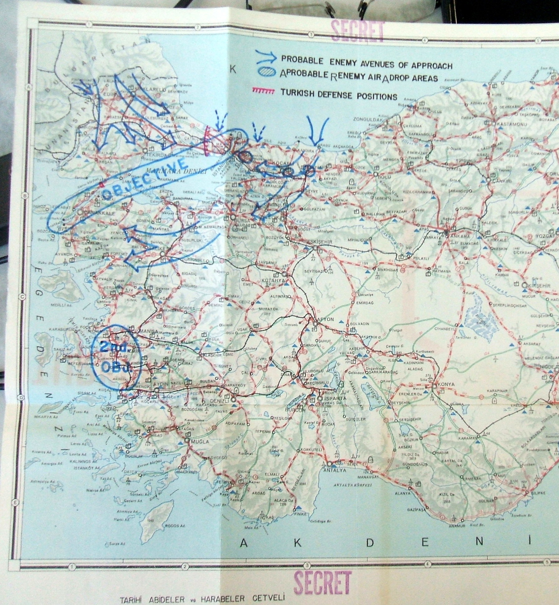
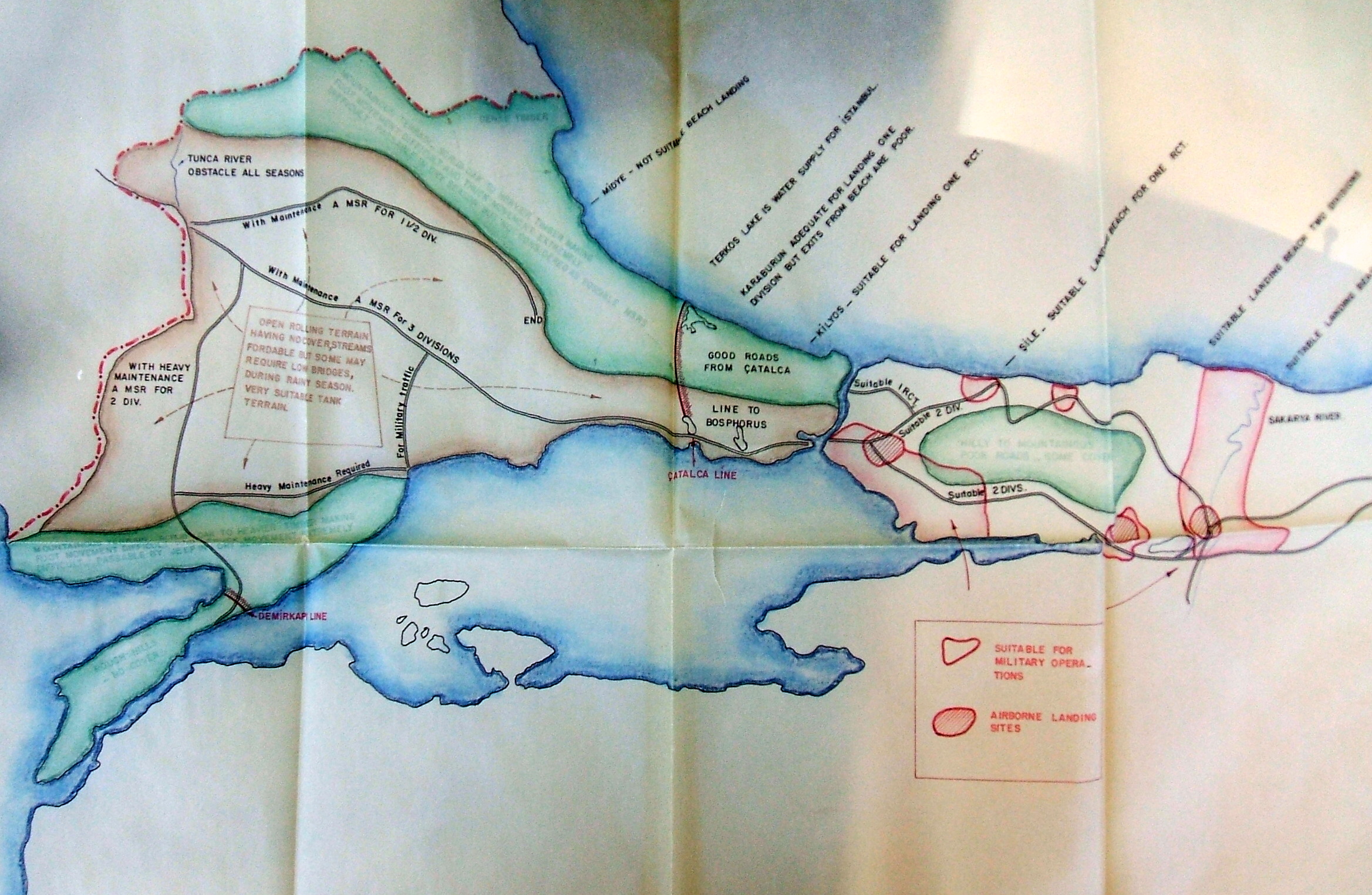
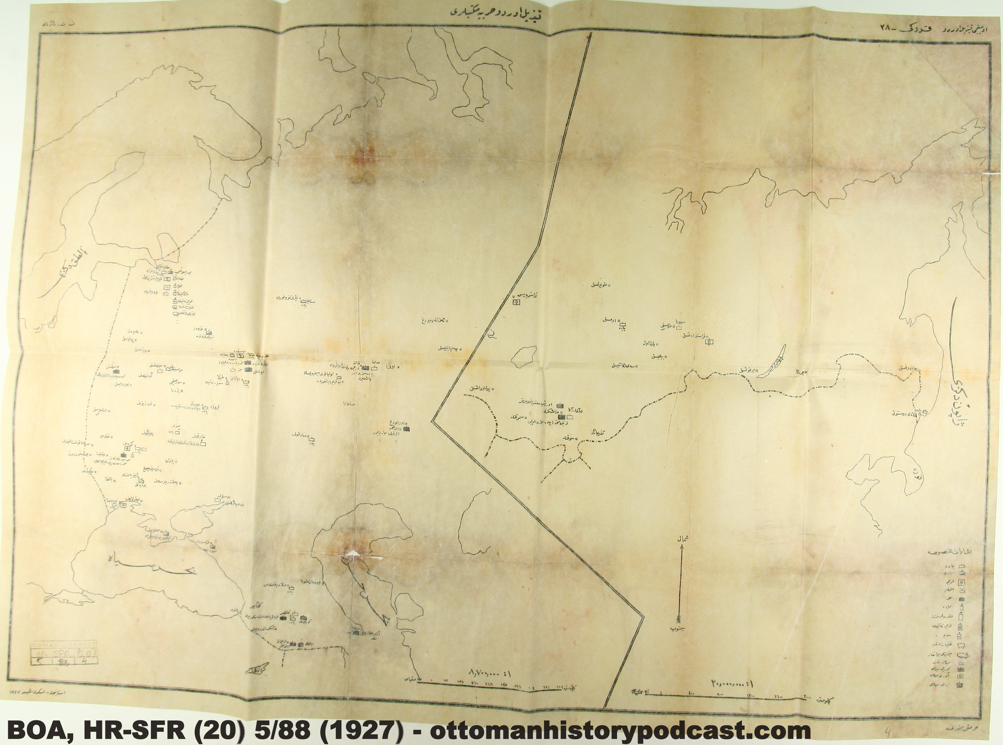
Probable Enemy Avenues of Approach    

Not - Bu harita 1950li yıllarda ABD hükumeti tarafından planlanan bir kanalı göstermiyor. Dikkatli bakarsanız, 'kanal'ın yanında "Çatalca Line" yazıyor, yani 'Çatalca Hattı'. Bu, II. Balkan Savaşı yıllarında bölgedeki ünlü savunma hattının adıdır. Bu harita Soğuk Savaş yıllarında Sovyetler Birliği'ne karşı boğazı koruma amaçlı hazırlanmış ortak bir savunma planını gösteriyor

30 years later, of course, Turkish-Russian relations were even worse. These maps, from the Joint American Military Mission for Aid to Turkey reflect early cold war American expectations about how the communists would attack Turkey. Though a good deal of strange conspiracy theories have arisen from the mistaken assumption that whatever the military makes plans for reflects its official policy, these maps at the very least are a reminder that at the time, an invasion like this and the world war it would trigger were considered real possibilities. The Turkish defense of Istanbul at this time was centered around the Catalca line, running across Thrace on the raised ground north of Buyukcekmece, the same point where the Ottoman army held off Bulgarian forces in 1913. A more controversial subject, between American military planners and their Turkish colleagues, was where America would mount its defense. One plan, understandably unpopular with Turkish leaders, involved writing off most of Anatolia and trying to stop the Russian advance into the Middle East at the Taurus mountains north of Adana.

Finally, though not suitable for an amphibious landing, Midye, now called Kiyikoy, is a delightful place for a weekend trip from Istanbul.

"A direct attack on the straights accompanied by an invasion from Bulgaria
The Soviets' ultimate destination was assumed to be the Suez.

Seeing Red: Military Intel in Early Republican Turkey and the Soviet Union

Russian Military Schools: for a full-sized version click here   

Just as the Russian and Ottoman Empires had been rivals for centuries, World War I saw the fall of these empires and their replacement with new states represented by the national Republic of Turkey and the Soviet Union. Entitled "Red Army Military Schools (Kızıl ordu harbiye mektepleri)," this map printed by the Turkish military in 1927 displays the locations of military schools and establishments of the new Red Army in Russia and the other Soviet republics such as Azerbaijan and Armenia.

One of the interesting facts about this map is that it was found in the records of the Ottoman/Turkish embassy in Tehran. While the Safavid and Qajars were generally rivals of the Ottomans, relations between these neighbors improved during the late nineteenth century, and under the new government of the Pahlavi dynasty and Reza Shah, Turkey led by Mustafa Kemal Atatürk entered into a new period of friendship and cooperation between the two states in 1926. This early alliance may have included coordination on matters of intelligence such as those found in this map.


Map Key
Soviet Central Asia
Sea of Japan
Caucasus
Baltic Region

Monday, January 21, 2013

Illustrated Economy

Nick Danforth, Georgetown University

Illustrated Economy: for a full sized version click here.

This map, also courtesy of the Ataturk Library, offers a colorful celebration of Republican Turkey's industrialization and agricultural wealth in the 1940s. There is a cheerful coal miner in Zonguldak, sardines from Canakkale, canned milk from Kars, an optimistic oil derrick in Batman and fluffy white buds of cotton from Cukurova. In the following decade, the debate over whether Turkey should focus on industrial development or prioritize agriculture (which was expected to provide the capital for eventual industrialization) would become one of the main points of contention between the Republican Peoples Party, which favored the former, and the Democratic Party, which favored the later.

The Marmara region, with the lovingly rendered smoke of Bursa's factories 
Planes and Pastirma: the perfect blend of tradition and modernity.

Intikam: Revenge 1914

Nick Danforth, Georgetown University


Revenge: for full size version click here    

This map, courtesy of the Atatürk Kitaplığı, is titled simply Intikam or Revenge. Published by the Rumeliya Muhacirin-i Islamiyesi Cemiyeti or Society of Muslim Refugees from Rumeliya, the map shows, in black, the part of the Ottoman Empire lost during the Balkan Wars from which these refugees fled. The region's most important cities, where many of these refugees had lived, appear in the small white circles. This map gives a sense of the political climate that contributed to the Ottoman decision to join World War One, as discussed by Mustafa Aksakal in The Ottoman Road To War in 1914, as well as the complications stemming from the fact that the country which stood between them and much of the European territory they wanted to retake, Bulgaria, was also a German ally. Ümit Üngor's Making of Modern Turkey, meanwhile highlights the role that a widespread desire for revenge played in shaping Ottoman policy toward Armenians during the war. (Those who want a nice map about Muslim refugees with slightly different politics than Üngor's should check out Justin McCarthy's Forced Migration and Mortality). Finally, by highlighting the feelings that the Ottomans' lost territory inspired, this map also offers a reminder of  what was so remarkable about Atatürk's decision to accept and embrace Turkey's present day borders.

"Rumeliya" with the cities of Komotini and Xanthi
A refugee, a warplane and a book, reading Revenge on both pages.


Saturday, January 19, 2013

The Well-Protected Domains Meet the Forbidden City: a map of Beijing

Ottoman Map of Beijing  (BOA, Y-PRK-EŞA 36/41, No. 1): For a full sized image click here.

During the Hamidian period, the Ottoman Empire, as any European empire might, sought to expand its global presence through building new connections with far-flung corners of the Muslim world. In a Episode 82 of the Ottoman History Podcast, Jeffery Dyer discussed the place of Zanzibar in this imperial imagination. China was another location where the Ottomans were among many governments testing their imperial limits.

Walls Of The Tartar City in Beijing
William H. Jackson, c1894-96

After all, China was home to a large Muslim community on the western frontier that was moreover largely Turkic, though the latter affinity could only be distantly relevant during that era. The Hamidian regime, through its support of Islamic institutions such as mosques and schools, could use its cultural capital to expand its sphere of influence and use Muslim populations as a potential bargaining chip in negotiations with European allies and rivals. In 1900, when Chinese Muslim troops became part of the Boxer Rebellion, Abdul Hamid II's government--upon the request of Kaiser Wilhelm--attempted to engage in correspondence with these troops from the Kansu province known as the "Kansu Braves" in hopes of bringing the rebellion to an orderly end. 

New relationships meant a need for new kinds of information, and during this late Ottoman period, the archive is full of bits and pieces of reconnaissance and efforts to gather information about the culture and society of empires such as China and Japan. This small map from the Başbakanlık Ottoman Archives shows an Ottoman attempt to depict the layout of the city of Beijing (then Peking). It was included in a folder describing attacks on the German ambassador and missionaries in the fervor of the Boxer Rebellion. The map resembles most European representations of Beijing from the era (here are two of them in English 1 | 2 ) and is irresistibly straightforward in its presentation of the city's layout, labeling only a few key places of interest such as temples, the "Chinese City," fortified "Tartar City," foreign legations, and institutions of learning. While the map is assumed to be based in part on European representations of the city, it may be worth noting the inclusion of a clock tower in the upper portion of the map as a major landmark given the preoccupation of Abdul Hamid II with erecting clock towers in every city of note within the well-protected domains.