Monday, December 29, 2014

Things in Prints

From: Racinet's "Le Costume Historique," Paris, 1888. Printed by Firmin Didot & Co.

The defining instinct of the traditional orientalist was to essentialize. Cataloguing diversity, somewhat  paradoxically, represented an integral tool for essentialization. Scholars devoted much of the 19th century to compiling encyclopedic entries showing variations on a theme – native pipes, native weapons, natives, mechanical objects and domestic animals – all in the hopes of better understanding the essence of these categories themselves. The results of such endeavors included scientific medicine and scientific racism. For those who got to enjoy the benefits of the former without the latter it was a great deal: no polio or discrimination. For those who suffered discrimination so severe they did not benefit from the good parts, it was an insidious tradeoff. For most everyone else, the result was something of a mixed bag.


Today the urge to catalogue lives on today as a singular 19th century aesthetic. Compiled below, from the amazing Flickr archives of the British Library, are some singular examples of the genre: “Diverse Objects,” Eskimo Knives, Earrings, Wash Tubs, Pigs, Bicycles, Criminal Types, Bulgarian Types, and so much more

Cassell's Illustrated History of the Russo-Turkish War

The Guide to Port Elizabeth. Illustrated

Palestine Past and Present

Six Years of Adventure in the Congoland

Antropologia generale. Lezioni su l'uomo secondo la teoria dell'evoluzione ... raccolte e pubblicate ... da G. Raverdino e G. B. Vigo

Dinosaurs, silk worms, blow darts and so much more after the break...

Monday, December 22, 2014

Merry Christmas from the Pyramids


The British, seen here enjoying a champagne Christmas lunch atop the Great Pyramid of Giza. Beneath the Union Jack. Surrounded by oriental beggars. Just in case last week's post made it seem like 19th century imperialism was all about freezing to death on the Russian steppe while making fun of your Turcoman guide's poetry. 

Friday, December 19, 2014

Pirates

Today's post is about Pirates. Unfortunately I don't have much information about the image at left, which I bought as is in Istanbul somewhere, but it appears to come from a 1950s of 60s book about Ottoman Algeria. The top to flags belong to the Beylerbeyi or head Ottoman official of Algeria. The next, with the skull and arm, is the flag of Algerian pirates. The arm alone is the banner of Algerian merchants, while the red white and green pennant belongs to merchant ships carrying government property. The wishbone(?) looking flag is the Commander's standard, while the final striped flag is for merchant ships carrying non-government property.

Of course, it's impossible to talk about pirates without talking about gender. As I've written about here before, I was drawn to the topic when I discovered Feridun Fazil Tulbentci's 1948 Hayrettin Barbarosa is Coming, which uses Ottoman history as a site to articulate a "modern" form of male sexuality.

More recently, though I stumbled on a fascinating article by Judith Tucker about gender and piracy in the in the Mediterranean. As with everything in history, it's complicated. You should read the whole thing, but in short, manfully fighting pirates could be a way to perform your masculinity, while being sodomized by pirates could call your masculinity into question. Also the threat that pirates represented to female virtue could, in the 16th and 17th centuries be a means of reinforcing patriarchy by keeping women off the high seas, but then, by the 19th century, also serve as a discourse justifying European colonialism in North Africa.

Alternatively, you can go directly to one of Professor Tucker's most engaging primary sources instead: "The Worthy Enterprise of John Fox, an Englishman, in Delivering 266 Christians out of the Captivity of the Turks at Alexandria, the 3rd of January, 1577." in all its glory, after the jump.

Monday, December 8, 2014

Cultural Prominence of US Cities Over Time


We're taking a break from the Middle East today to post a map that I made with Evan Tachovsky using Google Ngram to chart the literary popularity of different US cities over the course of the last two centuries. The version below uses a crude combination of word size and fonts to display both how frequently a city turns up in the English language today, as well as the era in which it was most talked about. The gif above offers a more precise view of how each city's popularity evolved over time. As explained in our original write-up for the New Inquiry, how surprising you find the results will depend on your preconceptions.


Las Vegas, it appears, carries less cultural weight than nearby Los Angeles. Meanwhile, Boston, having ceded its dominant role in American literary life nearly a century ago, continues to hold its own: with barely 300,000 people, it still looms larger in the language than LA. But more than anything, this map shows the enduring dominance of New York City, towering over the cultural landscape in a way that the map, with its pseudo-logarithmic scale can’t even do justice to. Were these letters written according to a more ordinary geometric scale (making Tucson visible to the naked eye) New York would blot out the entire Eastern Seaboard. And though it also proved impossible to show, for most of the 19th century Brooklyn appeared as often as Manhattan. That may in part have been on account of people simply referring to Manhattan as New York.

The map also reveals the unsurprising geography of America’s cultural development. New England had pride of place in the late 19th century, not only cities associated with the era’s high culture like Boston and Hartford (where Mark Twain moved in his later life) but also, say, Pittsburgh. Portland, Oregon’s prominence in this period is most likely the result of its post gold rush high, combined, one suspects, with the fact that its east coast eponym was also enjoying a period of maritime relevance at the time.

Confirming what everyone suspected, interest in the South peaked during the Civil War, with cities like Richmond, Savannah, Nashville and Charleston getting more mentions during the war or shortly thereafter than at any time since. Even Atlanta, one of the few Southern cities to emerge as a burgeoning cultural hub, was mentioned more the year it was burned down that at any point before the 1960s. (Bangor appears in part because it is the one of the few northern cities whose cultural influence also peaked in the 1860s. I can only assume this corresponds with the first telling of the “Bangor? Hardly even know her!” know joke.)

Omaha, Kansas City, Cleveland, and Detroit… these were the towns whose mystique and economic vitality seemed to vanish when the highways reached them. The same goes for Boise, Santa Fe, Salt Lake City and even all of Montana. Even Chicago, which sort of maintains on this map its claim to being the Second City, was never so popular as that moment in the 30s when it truly was hog butcher to the world. America’s shift westward is well-documented too, and many of the up-and-coming cities are the ones we would expect from this movement: Dallas, Minneapolis, Denver, San Francisco and Seattle.

Washington’s size proved too difficult to calculate on account of their being a state and a George with the same name, but it seems that references to Washington DC took off dramatically around the time of the New Deal, after being virtually nonexistent before, and then rose again with the expansion of the federal government in the 1970s. Needless to say, DC’s growth continues today.

Friday, November 21, 2014

The Myth of the Caliphate

The Round City of Baghdad, constructed by Abbasid Caliph al-Mansur and illustrated above by Naji el Mir. Today's post, taken from an article on Foreign Affairs, critiques the myth of the Caliphate as an enduring political institution. But honestly if any aspiring Caliph wants to rebuild a city that looks like such a cool, perfectly geometric map of itself I fully support them.

In 1924, Turkish leader Kemal Ataturk officially abolished the Ottoman caliphate. Today, most Western discussions of the Islamic State of Iraq and al-Sham (ISIS), the extremist group that has declared a caliphate across much of Iraq and Syria, begin by referencing this event as if it were a profound turning point in Islamic history. Some contemporary Islamists think of it this way, too: there’s a reason, for example, that Lion Cub, the Muslim Brotherhood’s children’s publication, once awarded the “Jewish” “traitor” Ataturk multiple first prizes in its “Know the Enemies of Your Religion” contest.

Even if today’s Islamists reference the Ottomans, though, most of them are much more focused on trying to re-create earlier caliphates: the era of the four Rightly Guided Caliphs, who ruled immediately after Muhammad’s death in the seventh century, for example, or the Abbasid caliphate, which existed in one form or another from the ninth to the thirteenth centuries (before being officially abolished by the Mongols). By conflating the nineteenth-century Ottoman royal family with these caliphs from a millennium ago or more, Western pundits and nostalgic Muslim thinkers alike have built up a narrative of the caliphate as an enduring institution, central to Islam and Islamic thought between the seventh and twentieth centuries. In fact, the caliphate is a political or religious idea whose relevance has waxed and waned according to circumstance.

The caliphate’s more recent history under the Ottomans shows why the institution might be better thought of as a political fantasy—a blank slate just as nebulous as the “dictatorship of the proletariat”—that contemporary Islamists are largely making up as they go along. (If it weren’t, ISIS could not so readily use the same term to describe their rogue and bloody statelet that Muslim British businessmen use to articulate the idea of an elected and democratic leader for the Islamic world.) What’s more, the story of the Ottoman caliphate also suggests that in trying to realize almost any version of this fantasy, contemporary Islamists may well confront the same contradictions that bedeviled the Ottomans a century ago.

OTTOMAN REBRANDING

Sunday, November 16, 2014

Africa Uncolonized?


Recently this cool map (below left) by Swedish artist Nikolaj Cyon has popped up in a few places, including Strange Maps and Africa is a Country. It shows one imaginative rendering of what Africa might look like today had the continent never been colonized by Europeans. Now I'm still hoping at some point to commission a definitive guest post about Ottoman maps of Africa from someone who knows more about them, but with Cyon's map making the rounds I thought it was only fair to share different set of imaginative cartographies addressing the same subject. Here is a distinctly non-European vision of how the political map of Africa should have looked if European imperialism had just been kept in check: behold Afrika-i Osmaniye.


Quite a few of the maps in Ottoman atlases from the late 19th and early 20th century boldly claim a large swath of Northeast Africa for the Ottoman Empire. In addition to preserving the fiction of Ottoman sovereignty over the Barbary Coast, Egypt and by extension Sudan long after these regions had been effectively taken over by England and France, these maps extend Ottoman claims to Somalia, Uganda and Kenya. Only Ethiopia, presumably since it had its own distinctly independent, definitively non-Muslim government, is excluded from this ambitious rendering of Ottoman Africa.

Anyways, everyone should check out Mostafa Minawi's podcast on the Ottoman Scramble for Africa to find out more about the politics of the period. Suffice it to say, the Ottomans seem to have been a century or so ahead of Nikolaj Cyon in imagining what Africa would have looked like without European colonization, and it looked an awful lot like Ottoman colonization. To be fair, these were Ottoman maps very clearly drawn in response to the Ottoman experience of European imperialism, but I think the broader point holds. What's striking about Cyon's map is that it quite openly reflects the legacy of Arab and Islamic influence in Africa. It seems entirely plausible that if we really tried to imagine an alternative history without Europe, Cyon's map would become a representation of Middle Eastern imperialism in Africa, and we would actually need some Saudi Cyon to come along and draw an imaginative cartography of how Africa might have looked free from that legacy.


Friday, November 14, 2014

From Florina to Golyazi: the other side of the Population Exchange

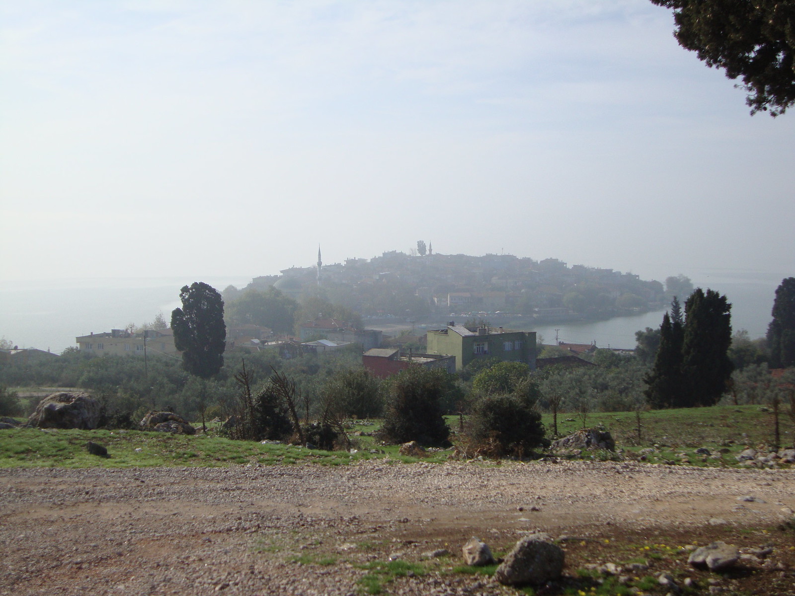
The town of Golyazi, with Ulubat Lake in the background, seen from the site of the former Greek cemetery.

20th century Turkish nationalism continues to offer Western journalists its fair share of dwindling ancient minority stories. There are the Greeks of Istanbul, the Jews of Antakya, the Suriyani of Mardin and the Armenians of Vakiflar, just to name a few. All powerful stories - and tragic - but read together they also suggest a tendency to fetishize the dying at the expense of the living. Maybe America, as a nation of successful immigrants, is particularly susceptible to a guilty fascination with the plight of those who remained behind. But we of all people should realize there is another side to the story.

The town of Golyazi lies on a lakeside promontory in a particularly beautiful part Anatolia just west of Bursa. Abandoned by deported Christians in 1923 and resettled by Muslims deported from northern Greece, it stands as something of a monument to both the cruelty and dislocation of the Turkish-Greek population exchange as well as the endurance of those who survived it. Golyazi has two graveyards, one destroyed and one still standing. The first evokes the loss of those deported, the second evokes the meaning of their post-deporation lives.

When I visited Golyazi with my father in October 2013, we had to ask a few people in order to find the site of the town's Greek cemetery. Once we got there we had to ask again to find out if we were really in the right place. The former graveyard was a field of bare, rough gravel on a hill overlooking the lake, marked by a few pomegranate trees and the husks of their dead fruit. Like all to many physical reminders of Anatolia's Christian inhabitants, it had been destroyed by the government, apparently bulldozed at the orders of a local mayor in the 1960s.  All too often these acts of destruction accompanied international conflicts, over Cyprus usually, in which minority populations and their history became victims in Greece and Turkey alike. Destruction often proceeded in a retaliatory fashion, Turkey demolished Orthodox churches, Greece converted abandoned mosques into stables.

An old shepherd, at work among the weeds and rocks, confirmed that this was the Greek cemetery, then began to tell us about its destruction. He was, in fact, was eager to express his outrage at the state's disrespectful treatment of the dead. He said he had insisted at the time that it was immoral to tear up a graveyard whatever the faith of the people buried there. And, he continued, though those who ordered the destruction never admitted their error, his view had subsequently received divine confirmation when, some nights after the work was finished, villagers saw a spectral blue light descend on the hilltop.

After hearing his story and admiring the view out over the lake, we walked down the hill to the Muslim cemetery, sprawling near the surprisingly well preserved remains of the Greek orthodox church on a road into the village.


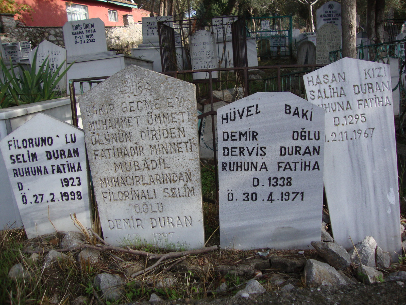
A group of graves facing the road caught our attention. Indeed, the epitaph on the oldest was designed to do just this -- "Ey Follower of Muhammet, Don't Just Glance and Pass By..." I was perhaps not the right person to recite a Fatiha, but reading the stones -- all bearing with the names of the now Greek cities where the interred had been born -- suddenly evoked a sense of the lives that had been built after the exchange. 
The inscriptions, from left to right, read as follows:


Selim Duran, from Filoruno [Florina], a prayer for his soul, born 1923, died 1998
Demir Duran, son of Selim, of Filorina, one of the population exchangees
Huvel baki, Dervish Duran, son of Demir Born 1338, died 1971
Saliha Duran, Daughter of Hasan, Born 1295, Died 1967


The dates span Turkey's conversion from the Islamic to Latin calendar, though Demir Duran's oldest son seems to have given his birthdate in Latin, the younger son in Hijra. But even with a rough estimate the advanced age of all the deceased becomes apparent. Selim Duran, for example, died at 75.

As Turkey has begun wrestling with the legacy of a century of nationalism, it is increasingly common to hear condemnation of the the population exchange that brought the Durans to Golyazi. Yet there is also something ahistorical, about this condemnation, almost a refusal to recognize the full extent of the 20th century's tragedies. Among other things, the population exchange is easier to talk about than the fate of the Armenians. There is a neat reciprocality to the exchange that makes makes nationalism the villain, not one particular nation.

But this is hardly a story unique to Turkey. In the history of much of 20th century Europe and the Middle East, deportees were the lucky ones. Here, by the lakeside, were the graves of an entire family that, after living out full lives, had been buried together, in graves laid out side by side, overlooking their new home. This was a fate reserved for all too few people in the last century.

Wednesday, November 12, 2014

Adorable WWI Propaganda


Source: germanpostalhistory.com


Of all the great WWI propaganda I've seen, these post-cards, courtesy of Chris Trapani  and Esin Pektas, are certainly the most endearing. Perhaps not as adorable as the Mini Mehter kids, they are way less ominous than most of the images to be found at GermanPostalHistory.com, where you can purchase your own original. If anyone knows anything more about these let us know. Germany, needless to say, is the one driving the wagon and giving Turkey an encouraging pat on the back in the second card.

If nothing else, though, these picture make me regret abandoning my kickstarter campaign to develop a line of child-sized Pickelhaube. The problem, as I recall, was that we couldn't decide whether to market them under the slogan "Baby Bismarck" or "Otto von Baby."


Anyways, if you want to see more martial babies just read on after the break. Apparently this is an entire genre. Seriously, does anyone know what the story is?

Tuesday, November 4, 2014

Geological Map of Turkey


These kinds of highly colorful 19th century geological maps are, I think, widely recognized as some of the most beautiful maps ever made. Come to think of it, they actually look a lot like ethnographic maps, but you can enjoy them without thinking about ethnic cleansing. Americans may be familiar with Harold Fiske's amazing 1944 map of the history of the Mississippi river, but needless to say you can find these maps for every country you want. Here's a nice one of Britain. Anyways, the image above is excerpted from a huge geological map of Europe. Click here for the whole thing.

Lest it seem as if, faced with the pressures of the fall semester, we have completely abandoned any serious political or historical analysis in favor of just publishing nice-looking maps, a quick story about the politics of geology in the map at left. I first came across this while compiling a series of maps illustrating the wide range of Turkish cartographic claims to Cyprus in the 60s and 70s. This one, needless to say, makes Cyprus appear a natural geologic extension of Turkey, with the island's two main mountain ranges being the continuation of the ranges that traverse Hatay. Needless to say, though, it turns out the maps published in the late 30s were all dedicated to showing that the mountain ranges of Hatay were natural extensions of the Taurus mountains, and therefore that Hatay was, geologically speaking, a natural part of Anatolia.

Ultimately among the many arguments advanced by nationalists for claiming particular territories over the years, geology has seldom been a prominent one. But, looking at these maps, its hard not to imagine an alternative history in which geologic rather than ethnic nationalism became the foundation for modern European states. Iceland, it appears, would emerge as the one pure Litho-state, built on a solid foundation of Trachyte and Basalt. A greater Scandinavia would also emerge, united by its common granite identity, after suppressing or assimilating minority regions of Devonian-era rock. England, in turn, would be the Balkans of this alternative world order, hopelessly divided between rival clans tracing their origins back to obscure fault-lines in the Eocene, Pliocene, and even Ordovician.


Wednesday, October 29, 2014

Hatay in History


Back when Hatay used to be the part of the Turkish-Syrian border everyone paid attention to, I thought it would be interesting to write up some of the things I discovered during my ill-fated effort to do research on the region's experience during the 1940s. Fortunately, I was able to join forces with Noga Malkin, who knew all about what was going on there now from her work with refugees in the region, and we put together an article on Hatay covering the past, present and future. Among other things, it discusses the status of refugees in Turkey, as well as the inescapable rumors of a special referendum in 2039 that could return the province to Syria. The article also serves as an opportunity to finally post this great map of Hatay (full size here) which Kerim Bayer sent me ages ago. When compared to a modern map, this one also shows, among other things, that the current province of Hatay is not the exact territory of the Sanjak of Alexandretta that became part of Turkey in 1939. Rather, the current Turkish province was extended to include some areas north of the former border to as to make the population of the territory as a whole more Turkish. 

Sunday, October 26, 2014

Chaldiran at 500


Given my ongoing fascination with the 500th anniversary of the conquest of Istanbul, I am excited to publish a guest post today from my friend Gennady Kurin about the commemoration (and non-commemoration) of the 500th anniversary of the Battle of Chaldiran in Iran. Gennady is currently a doctoral student at Cambridge researching Ottoman-Safavid relations. This cool Chaldiran graphic, designed by Mehdi Fatehi, can be seen at full size here.


The Five hundredth anniversary of the Battle of Çaldıran and how the Ottoman-Safavid conflict has shaped the Middle East.

The Middle East is rapidly changing. Yet, many crises the region is currently facing and the realities it lives with remain largely misunderstood. Here is an attempt at shedding some light on the past and the present of Turkey, Iran and everything in between as well as contextualizing some key factors determining the policies of these states, and showing how the shared history is used in constructing counterproductive political discourses.

Five hundred years ago on the 23rd of August, on a plain in northwestern Iran, today merely sixty kilometers from the Turkish border, a battle was fought inaugurating more than a century-long conflict between the Ottoman Empire and its eastern neighbor – the Safavid state. The immediate consequences of this battle and the many wars that followed were not just changes in the political landscape and redrawing of state borders. The religious and ideological dimensions of this clash have reshaped the Middle East, laid the foundations of some contemporary conflicts and can be said to have created Turkey and Iran as we know them today. Thus, anybody interested in the history and politics of this region can and should understand it in the context of the Ottoman-Safavid struggle.

While the world is passively watching the developments in Iraq and Syria and the Western countries are trying to decide what their policy towards the Islamic State should be, it is in fact Turkey and Iran that are key to finding long-term solutions to some of the problems the region is now facing. Having a history of military and religious-ideological struggle these two countries, willingly or not, seem to be slipping into another potentially very dangerous conflict with their support for either Sunni or Shi’a factions. And just like the ultimate outcome of this early modern sectarian conflict the current crisis is very unlikely to bring about anything other than chaos and destruction. This text should serve as an introduction to a series of articles about the conflict and how it has reshaped the region in question.

Tuesday, October 21, 2014

First (Copied) Ottoman Map of America


So I've already had to disappoint a few people who've written in about our Ottoman map of America by telling them that while this is, of course, an "Ottoman perspective" on the US, that has it's limits. The Ottomans weren't sending their own surveyors over, and this map was most likely based almost entirely on British sources. As the original draft of our Slate article on the map explained, in a paragraph that was unfortunately cut:

Information for early Ottoman maps of the new world was generally taken from the works of European cartographers, while by the later 19th century a number of Ottoman atlases were often purchased directly from British map-makers like George Philip & sons in London, who produced maps specifically for the Ottoman market.
 But I still had no idea just how closely the maker of this map had borrowed from European works until Juan Blanco was kind enough to write in and point me to the original from which Mahmoud Raif Efendi seems to have quite clearly worked. Above is British cartographer William Faden's 1796 map of the United States. What's fascinating is that almost all the text on the Ottoman version seems to be a direct translation of Faden's with the exception of the name of the United States of America. Fadden, of course, labels it the United States, while the Ottoman version calls it the Republic of the English People, or İngliz Cumhurunun Ülkesi.


Seeing how much the Ottoman cartographer copied directly from the British original makes those few points of departure all the more interesting. If anyone has any thoughts on what he did with Florida or what happened to the prominently marked "Western Territory" let us know.

Trans-Can Trucker


In addition to being an Ottoman History blog, Afternoon Map has also long aspired to be one of the leading Canadian Cartography Portals on the web. With that in mind, and, in part, to remind our readers of an earlier era where there was actually something worthwhile on the internet, we our devoting today's post to Trans-Canadian Trucker a cross-country (choose-your-own) adventure game slash Canadian coming of age story that takes you from Halifax to Vancouver in pursuit of some salt cod and maybe romance. Our only advice, before you choose your rig, is to make sure you stop at Tim Horton's...

Seriously. Play Trans-Canadian Trucker

The Other Side of WWI


To balance out our anti-German fear-mongering, not to mention our favorite maps showing the Ottoman Empire as a German colony, it seemed only fair to share this map offering a German perspective on World War One. Here are all the colonies of all of Germany's enemies in nice bright colors (though of course none of Germany's colonies are on there). I would love to know what this actually says. In any case it's hard to escape the conclusion that Germany really was missing out.

From Sotirios Dimitriadis: "The redress of injustice will be the foundation of a lasting peace" Lloyd George, January 5, 1918. According to the statement by Lloyd George, we can demand the following colonies from the Entente.

[In red:] The success of the 8th War Bond reflects the gratitude of the Homeland for the great victories in the West.

Wednesday, October 15, 2014

Lavrens

Erdogan recently made the news in the US with some comments about Lawrence of Arabia. Many Americans seem shocked that people in Turkey don't remember Lawrence as fondly as we do. But Erdogan, not surprisingly, is far from the first person in Turkey to to express such sentiments. Consider the 2006 movie Eve Giden Yol, which served as the slightly over the top Turkish response to Lawrence of Arabia. There was this fantastic scene of Lawrence visiting the tomb of Salahaddin, as well as a slightly different take on blowing up trains full of Turkish soldiers. But way before any of this was a remarkable obituary published on the occasion of Lawrence's death in the May 23, 1935 issue of the magazine Akbaba. Editor Yusuf Ziya Ortac, it should be noted, had some problematic political views of his own, but in these choice words for Lawrence he was echoing the thoughts of many in Turkey who had seen his post-war legend grow. Some highlights:

Istanbul is famous for its beauty, Ankara its will; Paris its liveliness, Viena its operas, Switzerland its Sanatoriums and England is famous for Lawrence.

In the deserts during the Great War the Turkish army's most feared microbe was him.

In Lawrence's death the world's gain is as great as England's loss. Now it is more possible for nations to love each other and work together for peace.

Lawrence's death. As with any great joy it isn't easy to believe the good news.

If Lawrence is really dead... in that case people face a new fear: the fear of the hereafter.


Below, Araplı Lawrence (left) from Eve Giden Yol


Perhaps the most ridiculous thing about all of this is that if anyone deserves credit for being the Lawrence of modern day Syria, it is undoubtedly Erdogan, who's spent the past three years supporting an Arab revolt. 

Monday, October 13, 2014

Was Your City's Major Diplomatic Achievement a Bust? Probably.


Today's map is a work in progress, we encourage readers to write in and suggest more cities and treaties. Some of these are clearly judgement calls, but the basic idea should be clear. A few cities are known for meaningful and lasting diplomatic achievements. Most are known for treaties that failed spectacularly.

Sunday, October 12, 2014

Hazreti Ali in the Valley of Death

"Hazreti Ali in the Valley of Death"

While Christians continue to argue about evolution, Hazreti Ali confidently chops up dinosaurs with his trusty zulfiqar. This is in fact a book from the 80s retelling a story about Ali's confrontation with a dragon (this site of which is apparently a tourist attraction in Afghanistan).

Suffice it to say this semester has been a busy one for me, which means the next few weeks will probably feature more dinosaurs and fewer lengthy discussions of maps. Fortunately we've got some excellent guest posts coming up as well and some weird maps we'll be calling on readers to try to explain.

Selami Munir Yurdatap
Saglam Kitapevi
Doyuran Matbaasi, 1982

Thursday, October 9, 2014

Kolorful Konya


Following up on Amazing Ankara, Beautiful Bursa and Superb Salonica, today we have  Kolorful Konya, from an 1891 American map of Turkey in Asia published by D. Appleton and Co (New York).

It's a beautiful map, but we're really just posting it as an excuse to reprint a poem about Konya from Bryan McCann. This year Professor McCann is leading Georgetown's semester abroad at the McGhee Center for Eastern Mediterranean Studies in Alanya. In addition to this poem, his blog features a unique comparative perspective on Turkey and Brazil, covering topics like human rights, street scams and Saint George.

Konya, O unlovely Konya, let us not speak ill of you. Dervish skirt of blank expanses and mystic core, I have seen your alleys crowded with gaunt men drinking tea. I have seen your covered women in the marketplace, heads down, not lingering. On your fringes I have seen two boys riding two bicycles, not one on each but two on one, towing the other by the hand. Why? Such knowledge, like much else, is forbidden me. I have seen your black-vested man driving the weather-beaten Audi 504c, left hand out the window to hold down the mattress on the roof, son standing at his right shoulder between the two front seats, older woman, covered in black shawl, in the back seat. 

Hittite roadstead, Seljuk redoubt, I have seen the geometric perfection of your turquoise-tiled madrassah. City of Rumi, where is the love? In your young men walking arm in arm. In your dervishes offering apple tea. Not in your vast and teeming traffic circles. City of cautious travelers, learning to whirl. Not so fast, yabanci. 

City of dusty walls, I have stayed in your Rumi Hotel. If the hotel is Rumi enough, there is always vacancy.

Monday, October 6, 2014

Kobani, War Games

I don't know if other people following the news from Kobani on Radikal have been struck by this as well, but the juxtaposition of banner ads for an online wargame and this particular map of military situation in Kobani is a little jarring. A slightly more in depth discussion of the issues involved here at The New Republic for anyone who is interested. 


Saturday, October 4, 2014

Debating Modernity on Kurban Bayrami

Today is the first day of what people in Turkey call Kurban Bayrami, a Muslim holiday better known as Eid. It's a chance to take a break from work, spend time with friends and family, and debate modernity.

To commemorate Abraham’s willingness to sacrifice his son on God’s orders, those who are religiously observant and who can afford it will participate in the tradition of purchasing sheep or cows, slaughtering them, and distributing the meat to the poor. Meanwhile, many members of Turkey’s self-consciously Western elite will participate in their own tradition: denouncing the whole thing as barbaric.

All too aware of how these things look to Western observers, Turkish secularists have long argued that animal sacrifice -- especially when it’s done with a knife illegally, in the street, in front of families, with kids in tow -- does not help Turkey in its many-decade struggle to appear modern. In that sense, the yearly Kurban Bayrami debate has been a textbook case study in the country’s culture wars: secularists condemn certain activities as backward, and religious conservatives defend them as vital Islamic traditions.

Alongside these two basic positions, however, there are a host of more surprising arguments, many put forward by pro-sacrifice conservatives eager to claim the modernist high ground. Read together, these arguments offer a more nuanced view of Turkish society and a window into the current Islamist government’s success.

Most, striking, if perhaps least common, are the hyper-progressive naturalist defenses of Kurban Bayrami sacrifices that pop up occasionally among a small set of young liberals: eating meat involves killing animals, and there is nothing more natural than acknowledging this fact publicly. Indeed, the sight of a fuzzy gray kitten contentedly lapping up fresh blood as it flows down the cobblestone streets -- as is common during the sacrifice -- seems to both justify and rebuke one's carnivorous urges.

Wednesday, October 1, 2014

Lausanne Maps

Having already done our part to promote the conspiracy that Erdogan’s Canal Istanbul was originally planned by the US in the 50s to circumvent the Montreaux Convention, we are excited to now push the story that the Lausanne Treaty will expire, or perhaps be up for review, on its hundredth anniversary in 2023. The real challenge for Turkey, of course, is that this time it won’t have the help of Ismet Inonu, a statesman whose cunning, combined with questionable translation, have led him to be described as “foxy.” Maybe in Ismet Pasa’s absence America can finally get the mandate that we missed out on last time. 


Recently, there's been a trend among critics of Turkey's Kemalist tradition to suggest that Lausanne was not in fact a historic achievement but rather a betrayal of the Turkish nation. Whereas Ataturk once implausibly suggested that if only the Ottoman Sultans had been more patriotic they could have maintained control of the Balkans and North Africa, Ataturk's modern critics use their newfound freedom to suggest if only Ataturk hadn’t been a British double agent he could have maintained Turkish control of Mosul and Thrace. It makes sense that the extreme emphasis on Lausanne in Kemalist historiography might have created this kind of backlash, particularly as Ismet Inonu's accomplishments have always been easier to criticize for conservative nationalists unwilling to attack Ataturk himself. And inevitably, as Turkey becomes stronger and more powerful, the context in which Lausanne seemed like such an accomplishment becomes harder for modern Turkish citizens to imagine. I don't necessarily think Turkey should revive the tradition, implemented by President Inonu, of celebrating Lausanne Day, complete with children dressed as parts of Anatolia, but all things considered it seems crazy not to acknowledge that, given the circumstances he was faced with, Inonu did a pretty good job at the negotiating table.


Anyways, here are some student maps that were displayed at the Pembe Kosk, Inonu’s former residence, as part of a Lausanne Anniversary art contest. The metaphors are mixed, but the results speak for themselves. In one case Lausanne is the thread stitching together the severed parts of Turkey, while in the other it's the key unlocking the chains that hold Turkey down/apart. Our third map hints at what may happen when Lausanne expires, illustrating a rather different political position in a remarkably similar visual style. Not only is there the traditional symbolism of breaking chains, but also that of a crazy Kurdish ninja star.


Oddly Gendered Odds and Ends


(Above: "A feminized man...")
(Left: Sold in the US under the names Metandren and Hormale, Hormobin was the Turkish name for the drug Methyltestosterone.)

Two random pictures from 1940s Turkish magazines I came across while reviewing research photos.  At the risk of essentializing gender constructs and ideals of masculinity across different decades and cultures, this pair of images seems to reflect the same dichotomy articulated so well by Sean Connery in The Rock: You're either the kind of guy who takes Hormobin or the kind of guy who sits around playing chess...

Skipping back to the late Ottoman Era, we're indebted to Ümüt Akagündüz's work for drawing out attention to a work by Ali Seydi Bey called Kızlara Mahsûs Târîh-i Osmânî,  or Ottoman History for Girls. You should check out the whole article but in short Ali Seydi Bey explains that women need to develop a sense of historically informed patriotism so they can pass it on to their male children, and has some cautionary examples from the Ottoman court about how bad wives can bring ruin to their husbands.

And if all that weren't exciting enough, the book also includes a version of one of our favorite maps from after the Balkan wars...


Monday, September 29, 2014

The Hoja at War


This image of Nasreddin Hoja at war comes from a 1952 publication called Kore Kahramanları (Heroes of Korea) celebrating Turkish-American friendship and the NATO alliance. By way of advice the Hoja offers the United Nations a piece of cold war wisdom so seemingly absurd that in other situations might be put in his mouth as a form of satire. Here, though, he seems completely earnest in advising: If you want peace, prepare for war.

For more Nasredding Hoja coverage, check out A Very Hojja Christmas. For more Cold War maps, here's some anti-communist propaganda, more anti-communist propaganda, and plans for defending against a Soviet invasion.

Tuesday, September 23, 2014

Uncle Sam Rolls Out the Magic Carpet


Today we have a few highlights from an amazing photo spread prepared by the United States Information Service documenting an American Air Force effort to fly Muslim pilgrims to Mecca for the 1952 Hajj season. Read the full article about Operation Hajji Baba, then check out some bonus photos below. The originals turned up in the remarkable US government photo repository on the third floor of the US National Archives at College Park.

Monday, September 22, 2014

Piri Reis versus Reality


A very nice compilation showing Piri Reis's 16th century work over a modern map of Europe. Some remarkable precision on the Mediterranean, but a little fuzzy around England and Scandinavia.

Monday, September 15, 2014

Canada in Confusion


In today's post we return to the always vexed question of Canadian borders and explore how the contemporary map of Canada took shape. Do the country's unremarkable borders, imposed by British imperialists a century ago, explain the unremarkable depths into which it subsequently plunged? Did the Durham - Sydenham Union Act sow the seeds of the region's present-day boringness? What if the map of Canada contained 14 provinces instead of however many provinces it actually has? And could the presence of an independent Athabasca have prevented the tensions that subsequently consumed mini-Manitoba? What if Keewatin and Ungava still maintained their sovereignty in the face of Quebecoise and Ontarian irredentism? Today's map forces us to consider the slightly more interesting country Canada could have been and ask "was a different future possible for our northern neighbor?"

For some genuinely interesting history about Canada's western provinces, check out this Canadian Geographic article.

Wednesday, September 10, 2014

Central Asia in Flux


A map that finally captures the confusion of the 1920s Soviet national delimitation in Central Asia, with the names of the region's new states super-imposed in red over an older map of the area. Even more exciting, it shows the region at the moment that Tajikistan has been upgraded to the status of full republic and the map-makers can't even find space to write its name in. Anyways, if you're interested, check out our short paper on the delimitation or a nice bit of 1950s Soviet Tajik propaganda.